 |
|
 27-03-2015, 15:36
|
#361
|
|
Registered User

Join Date: Dec 2005
Location: Helsingborg
Boat: Dufour 35
Posts: 3,891
|
Re: OpenCPN Version 4.0 Released
MMSI problem.
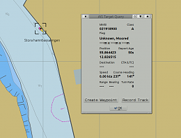
The MMSI number reported above - 021918900 - is not correct.
The leading "0" should not be there. Just search the net for
and look at the Marinetraffic page, to see that it's the same vessel = "Blue Alfa".
The AIS data is from the Baltic AIS tcp stream.
??
Thomas
|

|

|
|
27-03-2015, 16:14
|
#363
|
|
Registered User
Join Date: Jan 2010
Location: Portland, Oregon, USA
Boat: 31' Cape George Cutter
Posts: 3,286
|
Re: OpenCPN Version 4.0 Released
The MMSI that you received appears to be 9 digits, which is correct. You are noticing that there is a 0 added at the left and the last 0 dropped - which is also correct if the station wishes to create a "group" MMSI. In the US MMSIs received through the normal process for ships will receive a 9-digit number with a 0 in the last digit. Any such station may use a group ID determined by shifting right as described. MMSIs without a trailing 0 are given out to stations which get them without the full FCC Ship's license, and cannot create a group MMSI.
Greg
|
|
|
|
|
28-03-2015, 00:45
|
#364
|
|
Registered User
Join Date: Dec 2005
Location: Helsingborg
Boat: Dufour 35
Posts: 3,891
|
Re: OpenCPN Version 4.0 Released
Quote:
Originally Posted by nohal

|
Here you go!
Blue3.txt.doc
Thomas
|
|
|
|
|
28-03-2015, 09:22
|
#365
|
|
Registered User
Join Date: Dec 2005
Location: Helsingborg
Boat: Dufour 35
Posts: 3,891
|
Re: OpenCPN Version 4.0 Released
Tracker Problem....
The tracker is back up again. To me it looks like it has been restored from an old backup. I entered a new task the 17:th that's gone now. Nothing is entered between 2015-03-14 and 2015-03-28.
So... check your task entries and comments. They may have to be reentered.
Thomas
|
|
|
|
|
28-03-2015, 10:43
|
#366
|
|
Registered User
Join Date: Jan 2007
Location: Minneapolis
Boat: Irwin 37 CC
Posts: 665
|
Re: OpenCPN Version 4.0 Released
I don't know if this should be called a bug, nor do I have any older systems to try.
If you bring up waypoint properties (double click) you can move the waypoint selected and you can also move any other waypoint on the screen. I wouldn't have expected this.
__________________
David Kester
Pegasus IV
|
|
|
|
|
28-03-2015, 11:21
|
#367
|
|
Registered User
Join Date: Mar 2012
Location: Boston, MA
Boat: 1981 Bristol 32 Sloop
Posts: 17,660
|
Re: OpenCPN Version 4.0 Released
Yes this is a good explanation. Perhaps it should be made into a comment in the documentation wiki.
Sent from my SCH-I545 using Cruisers Sailing Forum mobile app
|
|
|
|
|
28-03-2015, 11:22
|
#368
|
|
Registered User
Join Date: Mar 2012
Location: Boston, MA
Boat: 1981 Bristol 32 Sloop
Posts: 17,660
|
Re: OpenCPN Version 4.0 Released
Above Re mmsi -- carnalpdx
Sent from my SCH-I545 using Cruisers Sailing Forum mobile app
|
|
|
|
|
28-03-2015, 14:25
|
#369
|
|
Registered User
Join Date: Dec 2005
Location: Helsingborg
Boat: Dufour 35
Posts: 3,891
|
Re: OpenCPN Version 4.0 Released
Quote:
Originally Posted by wdkester
I don't know if this should be called a bug, nor do I have any older systems to try.
If you bring up waypoint properties (double click) you can move the waypoint selected and you can also move any other waypoint on the screen. I wouldn't have expected this. |
It's not a bug .....it's a feature 
Options->>Display->>Advanced->> Lock Waypoints (Unless waypoint property dialog visible)
That option has been available, unchanged, for a long time.
Thomas
|
|
|
|
|
01-04-2015, 13:11
|
#370
|
|
Registered User
Join Date: Dec 2005
Location: Helsingborg
Boat: Dufour 35
Posts: 3,891
|
Re: OpenCPN Version 4.0 Released
Quote:
Originally Posted by CarinaPDX
The MMSI that you received appears to be 9 digits, which is correct. You are noticing that there is a 0 added at the left and the last 0 dropped - which is also correct if the station wishes to create a "group" MMSI. In the US MMSIs received through the normal process for ships will receive a 9-digit number with a 0 in the last digit. Any such station may use a group ID determined by shifting right as described. MMSIs without a trailing 0 are given out to stations which get them without the full FCC Ship's license, and cannot create a group MMSI.
Greg |
The problem with this argument is that group MMSI's is only used for DSC, not for AIS. Any ship in a group also has an individual MMSI, which should be used in an AIS.
More here for example-> Maritime Mobile Service Identity (MMSI) - Australian Maritime Safety Authority (AMSA)
Consequently the "Blue Alfa" seems to display a non valid AIS/MMSI.
I reacted to the fact that this target never turned from yellow to green. The yellow state went on for days. Eventually the change took place, without, as far as I can say, any code change in O.
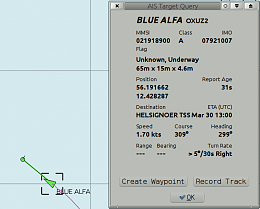
So is O just ignoring the leading "0" ?
Thomas
|
|
|
|
|
01-04-2015, 13:26
|
#371
|
|
Registered User
Join Date: May 2011
Location: underway whenever possible
Boat: Rangeboat 39
Posts: 4,759
|
Re: OpenCPN Version 4.0 Released
Thomas,
in the MMSITONAME.CSV at least the leading zeros are surpressed.
MRCC Madrid appears as 2241008 and should be 002241008
There are some more
Hubert
|
|
|
|
|
01-04-2015, 14:10
|
#372
|
|
Registered User
Join Date: Mar 2012
Location: Boston, MA
Boat: 1981 Bristol 32 Sloop
Posts: 17,660
|
Re: OpenCPN Version 4.0 Released
As I understand the group identiy scheme, is it allows "Group Calling" which should be adequately described in you Dsc/VHF manual. It allows group calling for fleets, friends, clubs, etc
Sent from my SCH-I545 using Cruisers Sailing Forum mobile app
|
|
|
|
|
01-04-2015, 14:29
|
#373
|
|
Registered User
Join Date: Mar 2010
Location: France
Boat: 10.50 mètres
Posts: 2,995
|
Re: OpenCPN Version 4.0 Released
Hello Thomas,
This concerns the wiki content in charts that OpenCPN can exploit.
here:
"Commercial Nautical Charts for OpenCPN"
and more specifically that:
"Windows only
The VisitMyHarbour "ChartSticks" USB sticks are covering UK, Ireland, Belgium, Netherlands, Spain (Including the Canary Islands) and Portugal (Including Madeira and the Azores) with UKHO rastercharts, updated yearly. Windows only. "
Since March, visitMyharbour has posted raster charts from SHOM for OpenCPN. This applies to raster charts of the French coast of the English Channel from Dunkirk in the north to Brest, western, and even a small part of the Atlantic coast of the French coasts from Brest to the islands Glénan.
Since March, visitMyharbour has posted raster charts from SHOM for OpenCPN. This applies to raster charts of the French coast of the English Channel from Dunkirk in the north to Brest, western, and even a small part of the Atlantic coast of the French coasts from Brest to the islands Glénan.
Can you add it to the wiki on the one hand, and the other manual.
Best regards. Gilletarom.
|
|
|
|
|
01-04-2015, 14:45
|
#374
|
|
Registered User
Join Date: Jan 2010
Location: Portland, Oregon, USA
Boat: 31' Cape George Cutter
Posts: 3,286
|
Re: OpenCPN Version 4.0 Released
Quote:
Originally Posted by cagney
The problem with this argument is that group MMSI's is only used for DSC, not for AIS. Any ship in a group also has an individual MMSI, which should be used in an AIS. |
Agreed. I was reacting to the comment that it was an invalid MMSI (it wasn't, for a group) and that it was 10 digits (9 digits were shown, which again was valid). A group MMSI shouldn't be transmitted by AIS as an identifier; it should be used for DSC calling only, and the appropriate receiving stations should recognize it but not ID themselves with it. So something is wrong, but with a single non-repeatable example it might be hard to find. Is it possible someone programmed the MMSI number wrong in the AIS? With only one reprogram allowed without sending the unit to a factory service center mistakes can take a while to fix...
Greg
|
|
|
|
|
03-04-2015, 08:14
|
#375
|
|
Registered User
Join Date: Dec 2005
Location: Helsingborg
Boat: Dufour 35
Posts: 3,891
|
Re: OpenCPN Version 4.0 Released
Quote:
Originally Posted by Gilletarom
Hello Thomas,
This concerns the wiki content in charts that OpenCPN can exploit.
here:
"Commercial Nautical Charts for OpenCPN"
and more specifically that:
"Windows only
The VisitMyHarbour "ChartSticks" USB sticks are covering UK, Ireland, Belgium, Netherlands, Spain (Including the Canary Islands) and Portugal (Including Madeira and the Azores) with UKHO rastercharts, updated yearly. Windows only. "
Since March, visitMyharbour has posted raster charts from SHOM for OpenCPN. This applies to raster charts of the French coast of the English Channel from Dunkirk in the north to Brest, western, and even a small part of the Atlantic coast of the French coasts from Brest to the islands Glénan.
Since March, visitMyharbour has posted raster charts from SHOM for OpenCPN. This applies to raster charts of the French coast of the English Channel from Dunkirk in the north to Brest, western, and even a small part of the Atlantic coast of the French coasts from Brest to the islands Glénan.
Can you add it to the wiki on the one hand, and the other manual.
Best regards. Gilletarom. |
Thanks for the info. The wiki is updated, and there is a new entry in the News".
Thomas
|
|
|
|
|
|
| Thread Tools |
Search this Thread |
|
|
|
| Display Modes |
Rate This Thread |
 Linear Mode Linear Mode
|
|
 Posting Rules
|
You may not post new threads
You may not post replies
You may not post attachments
You may not edit your posts
HTML code is Off
|
|
|
|
Advertise Here

 Recent Discussions Recent Discussions |
|
|
|
|
|
|
|
|
|
|
|
|
|
|
|
|
|
|
|
|
|
|
|
|
|
Vendor Spotlight |
|
|
|
|
|
|
|
|
|


