Cruisers Forum


Reply
  This discussion is proudly sponsored by:
Please support our sponsors and let them know you heard about their products on Cruisers Forums. Advertise Here
 
Thread Tools Search this Thread Rate Thread Display Modes
Old 18-01-2021, 15:45   #1
Registered User

Join Date: Jan 2021
Location: Scarsdale, NY
Boat: Island Packet 27
Posts: 7
NOAA chart boundaries -- how to remove?

A typical view of any area on Long Island Sound (my home area) will display red rectangles showing the boundaries of the various NOAA charts that make up the view. They are completely unnecessary and just clutter things up. Is there any way to remove them? Thanks, ML
mluskin is offline   Reply With Quote
Old 18-01-2021, 15:51   #2
Registered User
 
DMF Sailing's Avatar

Join Date: Jan 2021
Location: Somewhere in the Gulf of Maine
Boat: THEN: Indefatigable Bristol Caravel #172; NOW: 42 makes of other people's boats (and counting)
Posts: 874
Images: 6
Re: NOAA chart boundaries -- how to remove?

Quote:
Originally Posted by mluskin View Post
A typical view of any area on Long Island Sound (my home area) will display red rectangles showing the boundaries of the various NOAA charts that make up the view. They are completely unnecessary and just clutter things up. Is there any way to remove them? Thanks, ML
https://www.charts.noaa.gov/OnLineViewer/12354.shtml

Does this have it?
DMF Sailing is offline   Reply With Quote
Old 18-01-2021, 15:53   #3
Registered User

Join Date: Feb 2011
Posts: 1,102
Re: NOAA chart boundaries -- how to remove?

Go to view uncheck chart outlines.
Bye
P_Dub is offline   Reply With Quote
Old 18-01-2021, 17:02   #4
Registered User

Join Date: Jan 2021
Location: Scarsdale, NY
Boat: Island Packet 27
Posts: 7
Re: NOAA chart boundaries -- how to remove?

thx for prompt reply and pardon my ignorance, but i don't see a "view" box/selection. there's nothing in "options". what am i missing? ml
mluskin is offline   Reply With Quote
Old 18-01-2021, 17:18   #5
Registered User

Join Date: Feb 2011
Posts: 1,102
Re: NOAA chart boundaries -- how to remove?

If you are in Windows:-
Upper left cornr:-
Navigate View Ais Tools Help
open View and you will see Chart outlines.
Bye
P_Dub is offline   Reply With Quote
Old 19-01-2021, 04:37   #6
Registered User

Join Date: Jan 2021
Location: Scarsdale, NY
Boat: Island Packet 27
Posts: 7
Re: NOAA chart boundaries -- how to remove?

Got it at last, thanks. Had to click Interface Options first to restore the Menu Bar, then go into View as you instructed. All fine now. ML
mluskin is offline   Reply With Quote
Old 19-01-2021, 14:58   #7
Registered User

Join Date: Oct 2014
Posts: 274
Re: NOAA chart boundaries -- how to remove?

Quote:
Originally Posted by mluskin View Post
Got it at last, thanks. Had to click Interface Options first to restore the Menu Bar, then go into View as you instructed. All fine now. ML
The Alt key will toggle the Menu Bar on or off. It works well on a Windows computer with a keyboard. The chart canvas needs to have "the focus". It won't work if a dialog box has the focus.

The Chart Outlines can be toggled on or off from the Chart Panel Options menu. This menu is opened or closed using the menu button (3-bar icon sometimes called a "hamburger") that is in the bottom-right corner of the chart canvas.

Here is a screen shot:

Click image for larger version

Name:	Chart_Panel_Options.png
Views:	36
Size:	288.5 KB
ID:	230696

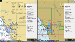
The two panel layout for the screen was enabled by using the menu under the top-left menu button on the chart canvas. Select Options, Display, General tab and Canvas Layout. Click on the picture of the one or two-panel layout.

The screen shot shows charts near San Francisco. Raster charts (RNC) on the left and vector charts (ENC) on the right.

Paul
.Paul. is offline   Reply With Quote
Old 19-01-2021, 16:00   #8
Registered User

Join Date: Jan 2021
Location: Scarsdale, NY
Boat: Island Packet 27
Posts: 7
Re: NOAA chart boundaries -- how to remove?

thanks, very helpful, lots to learn but this makes it easier. ml
mluskin is offline   Reply With Quote
Old 21-01-2021, 04:58   #9
Registered User

Join Date: Dec 2005
Location: Helsingborg
Boat: Dufour 35
Posts: 3,891
Re: NOAA chart boundaries -- how to remove?

The simplest way to turn chart outlines on/off, is the "O"- key shortcut.
cagney is offline   Reply With Quote
Reply

Tags
aries

Thread Tools Search this Thread
Search this Thread:

Advanced Search
Display Modes Rate This Thread
Rate This Thread:

Posting Rules
You may not post new threads
You may not post replies
You may not post attachments
You may not edit your posts

BB code is On
Smilies are On
[IMG] code is On
HTML code is Off
Trackbacks are Off
Pingbacks are Off
Refbacks are Off


Similar Threads
Thread Thread Starter Forum Replies Last Post
Boundaries in AusENC S-63 charts aboon OpenCPN 1 03-06-2018 17:30
Needed: Ocpn_draw boundaries for the Caribbean Islands rgleason OpenCPN 1 03-05-2018 16:32
Pink dashed Boundaries, cm93 maps, dont wish to view them sdowney1 OpenCPN 15 06-09-2015 11:31
School me on crossing National boundaries B310Racer Rules of the Road, Regulations & Red Tape 10 05-08-2015 20:02
Depth Boundaries tontario OpenCPN 6 24-06-2010 12:41

Advertise Here


All times are GMT -7. The time now is 20:02.


Google+
Powered by vBulletin® Version 3.8.8 Beta 1
Copyright ©2000 - 2024, vBulletin Solutions, Inc.
Social Knowledge Networks
Powered by vBulletin® Version 3.8.8 Beta 1
Copyright ©2000 - 2024, vBulletin Solutions, Inc.

ShowCase vBulletin Plugins by Drive Thru Online, Inc.