 |
|
 20-11-2019, 10:25
|
#1
|
|
Registered User

Join Date: Oct 2009
Location: Bermuda
Boat: Privilege 435
Posts: 586
|
How to get weather forecasts whilst offshore?
I realize that there are plenty of previous posts discussing this topic but the technology seems to change by the month and I wanted an up-to-date opinion on what is the easiest system to use for getting weather forecasts/grib files whilst cruising offshore in the North Atlantic/Caribbean area.
I have a Garmin Inreach which is great for staying in touch and it can download marine weather but it will only provide you with a forecast for one place which isnt a lot of help if you are sailing and planning a route.
Thanks in advance.
|

|

|
|
20-11-2019, 11:06
|
#2
|
|
Registered User
Join Date: Jun 2019
Posts: 2,707
|
Re: How to get weather forecasts whilst offshore?
Quote:
Originally Posted by Privilege

I have a Garmin Inreach which is great for staying in touch and it can download marine weather but it will only provide you with a forecast for one place which isnt a lot of help if you are sailing and planning a route.
Thanks in advance. |
I like the PredictWind product, though it's a bit pricey at $240/year, though there are less expensive packages (and one more expensive). Includes weather routing and route planning using proprietary GFS and Euro models. For route planning, you can enter your polars. If you are outside of cell-phone coverage, IridiumGO ($700 for hardware; unlimited data $150/mo, but you can shut-down when you don't need it).
|
|
|
|
|
21-11-2019, 00:55
|
#3
|
|
Registered User
Join Date: Nov 2019
Posts: 1,642
|
Re: How to get weather forecasts whilst offshore?
Quote:
Originally Posted by Privilege
I realize that there are plenty of previous posts discussing this topic but the technology seems to change by the month and I wanted an up-to-date opinion on what is the easiest system to use for getting weather forecasts/grib files whilst cruising offshore in the North Atlantic/Caribbean area.
I have a Garmin Inreach which is great for staying in touch and it can download marine weather but it will only provide you with a forecast for one place which isnt a lot of help if you are sailing and planning a route.
Thanks in advance. |
First you need a program for your computer that can read GRIB files
These are the files that contain the weather data
I have been using Weather Track for IPAD for many years...it is simple , sophisticated , reliable and includes a basic routing program
https://www.weathertrack.us/ipad.html
To recieve the data you will need long range communications ...Satellite or SSB
Read the info on the link to understand your communication options
Programs like windy are available ...i have no experience
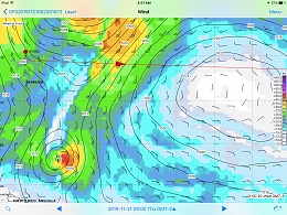
This is a weather track grib for that silly you tube cat. Transatlantic
That tropical low down south was forecast last week
They should have seen it
|
|
|
|
|
21-11-2019, 02:16
|
#4
|
|
Registered User
Join Date: Dec 2010
Location: W Carib
Boat: Wildcat 35, Hobie 33
Posts: 13,485
|
Re: How to get weather forecasts whilst offshore?
There are lots of options, but the easiest (as you specified) is probably to get IridiumGo + a good app/service for weather data (some recommended above).
|
|
|
|
|
21-11-2019, 02:42
|
#5
|
|
Registered User
Join Date: Jan 2012
Location: Vancouver, Canada
Boat: Beneteau Idylle 1150
Posts: 666
|
Re: How to get weather forecasts whilst offshore?
We have used an IridiumGo and PredictWind for several years in Mexico and then the Pacific across to French Polynesia. It worked very well - well enough to make the cost worthwhile. There are so many people using this setup that PredictWind seems to keep investing money to make their system even better.
We also have an HF/SSB (ICom 802) with Pactor modem on board which we sometimes use for synoptic files to provide a bigger picture.
__________________
Desolation Island is situated in a third region, somewhere between elsewhere and everywhere.
Jean-Paul Kauffmann
|
|
|
|
|
21-11-2019, 10:11
|
#6
|
|
Registered User
Join Date: Feb 2011
Location: Meandering about the Gulf of Alaska coast [NNE Pacific] where the internet doesn't always shine... [Even Elon's...] Homeport: Wrangell Island
Boat: Nauticat 43 [S&S Staysail Ketch]
Posts: 1,677
|
Re: How to get weather forecasts whilst offshore?
We have been using UUplus Personal Edition with our Iridium sat phone for years for email, to download GRIB files, WeFax, Satellite imagery, Wx forecasts, etc. For us, since we are full time, it is still cheaper [by about half] than an Iridium Go with unlimited data plan.
We have an Icom M802 with Pactor modem for back-up, but find it less reliable in higher latitudes.
Specific to gribs, and because we use Macintosh computers, we really like the LuckGrib program. Very powerful. And as a one time add-on it offers a variety of ways to download GRIBs via restricted bandwidth [e.g., sat phone, Iridium GO, weak cell signal, etc...] There is even an option to integrate with UUplus- which is perfect for us.
[If you are interested, there are many more details on our sat comms page.]
If we were making ocean passages on an ongoing basis, I would deeply investigate what other respected cruising friends have successfully relied upon: Predict Wind services via Iridium Go. They have been deemed very accurate and reliable by many ocean cruisers.
In case any of this is useful.
Cheers! Bill
__________________
SV Denali Rose
Learning every day- and sharing if I can.
|
|
|
|
|
21-11-2019, 13:45
|
#7
|
|
Registered User
Join Date: Jan 2011
Location: The Netherlands
Boat: Victoire 1122
Posts: 109
|
Re: How to get weather forecasts whilst offshore?
KISS: SSB radio ! For instance a "Winradio"; is a Black box radio connected to a computer. several possibilities to receive and file weateher forecasts. Even spoken messages can be recorded. WiNRADiO WR-G33EM Marine Receiver
|
|
|
|
|
22-11-2019, 02:33
|
#8
|
|
Registered User
Join Date: Jun 2003
Location: Chesapeake Bay
Boat: HR 40
Posts: 3,651
|
Re: How to get weather forecasts whilst offshore?
Quote:
Originally Posted by Privilege
I realize that there are plenty of previous posts discussing this topic but the technology seems to change by the month and I wanted an up-to-date opinion on what is the easiest system to use for getting weather forecasts/grib files whilst cruising offshore in the North Atlantic/Caribbean area.
|
Synoptic charts over weather fax are still the best available weather product. See Boston and New Orleans for products and schedules for your cruising area https://www.nws.noaa.gov/os/marine/rfax.pdf .
You can use an HF/SSB radio and Pactor modem to receive and get a lot of other benefits. Alternatively a $100 SSB-capable shortwave radio and a few bits and bobs to do the same thing. You can also receive the HF voice weather forecasts with the same gear.
The Tecsun PL-880, audio cable, antenna, and power I carry on delivery takes about 20 minutes to set up on a boat I've never been on before. Then it just sits there and works.
Gribs do not show fronts which are one of the most important elements of accurate weather forecasting on passage. They are easy but wrong. *sigh*
Quote:
Originally Posted by Marathon1150
We also have an HF/SSB (ICom 802) with Pactor modem on board which we sometimes use for synoptic files to provide a bigger picture.
|
Weather IS a big picture. Gribs provide some supplemental information. Given a choice between synoptics and gribs, synoptics are a clear winner.
https://ocean.weather.gov/shtml/A_brief.php
__________________
sail fast and eat well, dave
AuspiciousWorks
Beware cut and paste sailors
|
|
|
|
|
22-11-2019, 12:59
|
#9
|
|
Registered User
Join Date: Jul 2012
Location: North East USA
Boat: 1975 Tartan 41'
Posts: 1,044
|
Re: How to get weather forecasts whilst offshore?
I only crossed 1 ocean (sorta, NJ straight to St.Martin) so I kept it cheap... In-reach for weather forecast And 'FastSeas" (~$65 / Year) subscription that will text the in-reach weather routing between 2 points including wind velocity. It can be set up to route around high winds... so that's something.
For the big picture, I bought a 'world radio' for ~$150 and connected that to my computer to get "Weather Fax" using free JVcomm32 Demo software. Worked OK, bit of a PITA and the fax quality wasn't wonderful. But it's very cheap. See attached for typical quality... not sure how that compares to SSB and Practor modem?
Once I was island hopping I just used cellular, in the Caribbean and never needed anything else
|
|
|
|
|
22-11-2019, 19:16
|
#10
|
|
Registered User
Join Date: Jun 2019
Posts: 2,707
|
Re: How to get weather forecasts whilst offshore?
Through 2004, I was a full-time delivery captain out of San Francisco so mostly long runs. I then took a job in corporate America which was great, but kept me off the water. I'm back and getting ready to cruise, but am so rusty and so much has changed in wx products. I feel a bit like Rip Van Winkle.
I've used GRIBs via IridumGO and PredictWind for about a year and like it a lot, but something was missing compared to the old weather faxes I was used to. This thread brought it together for me. Frankly, I didn't know they were called synoptic charts, it's just what rolled off the wxfax printer every few hours.
Question : are these NOAA wx products available in a format suitable for IridumGO? Small file format? I too miss the fronts and the arrows showing moving of pressure systems. Over time, I got to know each NOAA forecaster's style pretty well, even met a couple (is Lee Chesneau still around?).
__________________
_______________________________________
Cruising our 36-foot trawler from California to Florida
Join our Instagram page @MVWeebles to follow along
|
|
|
|
|
22-11-2019, 20:01
|
#11
|
|
Registered User
Join Date: Mar 2008
Location: Calgary, AB, Canada
Posts: 6,252
|
Re: How to get weather forecasts whilst offshore?
Quote:
Originally Posted by mvweebles
Through 2004, I was a full-time delivery captain out of San Francisco so mostly long runs. I then took a job in corporate America which was great, but kept me off the water. I'm back and getting ready to cruise, but am so rusty and so much has changed in wx products. I feel a bit like Rip Van Winkle.
I've used GRIBs via IridumGO and PredictWind for about a year and like it a lot, but something was missing compared to the old weather faxes I was used to. This thread brought it together for me. Frankly, I didn't know they were called synoptic charts, it's just what rolled off the wxfax printer every few hours.
Question : are these NOAA wx products available in a format suitable for IridumGO? Small file format? I too miss the fronts and the arrows showing moving of pressure systems. Over time, I got to know each NOAA forecaster's style pretty well, even met a couple (is Lee Chesneau still around?). |
You can get weatherfax images through saildocs via IridiumGo.
I also use salidocs to get grib files and use SailGrib WR to read them.
__________________
CRYA Yachtmaster Ocean Instructor Evaluator, Sail
IYT Yachtmaster Coastal Instructor
As I sail, I praise God, and care not. (Luke Foxe)
|
|
|
|
|
22-11-2019, 20:21
|
#12
|
|
Registered User
Join Date: Mar 2008
Location: Calgary, AB, Canada
Posts: 6,252
|
Re: How to get weather forecasts whilst offshore?
Quote:
Originally Posted by mvweebles
Question : are these NOAA wx products available in a format suitable for IridumGO? Small file format? I too miss the fronts and the arrows showing moving of pressure systems. Over time, I got to know each NOAA forecaster's style pretty well, even met a couple (is Lee Chesneau still around?).
|
Instructions in this file:
https://tgftp.nws.noaa.gov/fax/ftpmail.txt
I met Lee a few years ago at the Vancouver Boat Show.
__________________
CRYA Yachtmaster Ocean Instructor Evaluator, Sail
IYT Yachtmaster Coastal Instructor
As I sail, I praise God, and care not. (Luke Foxe)
|
|
|
|
|
22-11-2019, 21:40
|
#13
|
|
Registered User
Join Date: Jul 2017
Location: Hobe Sound FL
Boat: PDQ 41
Posts: 58
|
Re: How to get weather forecasts whilst offshore?
I use weather routing, and talk to them twice a day on satphone. Beyond that, predict wind, but I always feel better talking to a professional who is doing weather 24/7
Best,
Maldwin
|
|
|
|
|
23-11-2019, 12:59
|
#14
|
|
Registered User
Join Date: Oct 2014
Location: Guatemala
Boat: Cheoy Lee PH43
Posts: 40
|
Re: How to get weather forecasts whilst offshore?
I also use Garmin Inreach. It allows you to enter the coordinates for a specific location, not just your actual location. At sea I enter coordinates for 100 miles ahead of current location. Pretty basic but just wanted to point out that it's not restricted to current location.
|
|
|
|
|
23-11-2019, 13:05
|
#15
|
|
Registered User
Join Date: Jun 2003
Location: Chesapeake Bay
Boat: HR 40
Posts: 3,651
|
Re: How to get weather forecasts whilst offshore?
Quote:
Originally Posted by mvweebles
Question : are these NOAA wx products available in a format suitable for IridumGO? Small file format? I too miss the fronts and the arrows showing moving of pressure systems. Over time, I got to know each NOAA forecaster's style pretty well, even met a couple (is Lee Chesneau still around?).
|
Sure - you can get the .gif and .tiff NOAA OPC WX products from Saildocs or directly from NOAA over ftpmail using Iridium GO!. They are not small. Small is what gribs are good at.
Lee had a stroke early this year. Last I heard from him he had moved to a nursing facility (between hospital and home). Thanks for reminding me that I'm overdue to call his wife and check in.
__________________
sail fast and eat well, dave
AuspiciousWorks
Beware cut and paste sailors
|
|
|
|
|
|
| Thread Tools |
Search this Thread |
|
|
|
| Display Modes |
Rate This Thread |
 Linear Mode Linear Mode
|
|
 Posting Rules
|
You may not post new threads
You may not post replies
You may not post attachments
You may not edit your posts
HTML code is Off
|
|
|
|
Advertise Here

 Recent Discussions Recent Discussions |
|
|
|
|
|
|
|
|
|
|
|
|
|
|
|
|
|
|
|
|
|
|
|
|
|
Vendor Spotlight |
|
|
|
|
|
|
|
|
|


