 |
|
 04-02-2015, 08:58
|
#76
|
|
Registered User

Join Date: Oct 2005
Location: Presently on US East Coast
Boat: Manta 40 "Reach"
Posts: 10,108
|
Re: The Electronic Charting "Zoom Problem"
Let me remind you of the premise you started the thread with.
"We all know how dangerous it is to rely on electronic charting for passage planning"
This is manifestly false - as you have been told several times in this thread. I have attempted to disassemble poor arguments given to support that premise.
You can fling an ad hominem about me arguing, but from my viewpoint, you are arguing and digging in. If you refuse to be challenged, and need to have your beliefs and views accepted without question, you should have stated so up front.
I stated there may certainly be places where vector charts on electronic devices may not be as easy for some to plan with as a large paper chart. So be it.
Likewise, there are places where paper charts don't even really exist to any useable extent, which electronic charts fully cover (we are in one of those places now). So be it.
And there are places like you were in where raster charts are available. So use them instead of vector. Get display goggles if you want an immersive experience with a large size format.
Tools exist now for determining hazards regardless of charting level. They are not on every single charting program or chart plotter, but that is a marketing problem. Vote with your money - there is no reason to stick with something that doesn't work for you.
And yes, I do believe that properly using tools is the onus of the operator. It may be that the grail you seek is unobtainable, but that doesn't damn the tool and remove the responsibility from the operator.
So, can things be improved? Always. Are you barking up the wrong tree in this thread? Somewhat - you are narrowly defining a small non-universal need that has the potential of bringing forth solutions that can cause a much larger problem
Mark
__________________
www.svreach.com
You do not need a parachute to skydive. You only need a parachute to skydive twice.
|

|

|
|
04-02-2015, 09:25
|
#77
|
|
Moderator

Join Date: Mar 2009
Location: Denmark (Winter), Helsinki (Summer); Cruising the Baltic Sea this year!
Boat: Cutter-Rigged Moody 54
Posts: 33,839
|
Re: The Electronic Charting "Zoom Problem"
Quote:
Originally Posted by colemj

Let me remind you of the premise you started the thread with.
"We all know how dangerous it is to rely on electronic charting for passage planning"
This is manifestly false - as you have been told several times in this thread. I have attempted to disassemble poor arguments given to support that premise.
You can fling an ad hominem about me arguing, but from my viewpoint, you are arguing and digging in. If you refuse to be challenged, and need to have your beliefs and views accepted without question, you should have stated so up front.
I stated there may certainly be places where vector charts on electronic devices may not be as easy for some to plan with as a large paper chart. So be it.
Likewise, there are places where paper charts don't even really exist to any useable extent, which electronic charts fully cover (we are in one of those places now). So be it.
And there are places like you were in where raster charts are available. So use them instead of vector. Get display goggles if you want an immersive experience with a large size format.
Tools exist now for determining hazards regardless of charting level. They are not on every single charting program or chart plotter, but that is a marketing problem. Vote with your money - there is no reason to stick with something that doesn't work for you.
And yes, I do believe that properly using tools is the onus of the operator. It may be that the grail you seek is unobtainable, but that doesn't damn the tool and remove the responsibility from the operator.
So, can things be improved? Always. Are you barking up the wrong tree in this thread? Somewhat - you are narrowly defining a small non-universal need that has the potential of bringing forth solutions that can cause a much larger problem
Mark |
Almost none of this really contradicts what I have been saying -- most of it is just argument for argument's sake.
Maybe I overstated the case with the sentence you quoted, but that does not invalidate the exercise. It is dangerous, when done improperly, and it is easy to do improperly with the tools we have today.
Now are we talking about a "small, non-universal need" or a "large, fairly widespread need"? That is an actual question with substance, which could be the subject of a non-idiotic discussion.
As I've said, the fact that you don't have -- or don't perceive -- a problem in your own methods and cruising grounds, does not prove that the problem doesn't exist. You could be either overconfident in your own capabilities, or you don't sail where you need these abilities, or both (I'm betting on "both"). I'm betting that if you had asked the navigator of Team Vestas, the day before the race, whether his skills and methods were adequate to avoid running into islands, he would not have hesitated to say "Of course, are you crazy? I'm a top racer, and a Yachtmaster Ocean! I have all the training and skills to avoid even the slightest risk of running into an island!"
So, as I've suggested, before you hubristically dismiss other's problems with these methods and tools, you might walk a mile in their boots. I have no doubt that the navigator of Team Vestas is a far better sailor and far better navigator than I am, which is one reason why I consider the accident to be such a wakeup call and so relevant. And that there are lots and lots and lots of lesser sailors, maybe including me, maybe including you, who overestimate their own skills, and who could be helped not only by more practice, skill and care ("responsibility of the operator"), but also by tools which work better.
|
|
|
|
|
04-02-2015, 10:32
|
#78
|
|
Registered User
Join Date: Oct 2011
Boat: Valiant 42
Posts: 6,008
|
Re: The Electronic Charting "Zoom Problem"
Dockhead,
Let's discuss facts. Find us a vector chart that "hides" a hazard when zoomed out? I keep hearing of them and when I go look at my vector charts the hazard is shown at all zooms. I'm needing a clear example. I have CM93 and all US vector charts so pick any place these cover.
|
|
|
|
|
04-02-2015, 10:51
|
#79
|
|
Moderator
Join Date: Mar 2009
Location: Denmark (Winter), Helsinki (Summer); Cruising the Baltic Sea this year!
Boat: Cutter-Rigged Moody 54
Posts: 33,839
|
Re: The Electronic Charting "Zoom Problem"
Quote:
Originally Posted by transmitterdan
Dockhead,
Let's discuss facts. Find us a vector chart that "hides" a hazard when zoomed out? I keep hearing of them and when I go look at my vector charts the hazard is shown at all zooms. I'm needing a clear example. I have CM93 and all US vector charts so pick any place these cover.
|
Yes, gladly. It is really striking how this occurs, and it will be useful to post examples. I will collect some in the course of the evening.
I will take screen shots from my plotter, and from INavX, as well as INavX.
|
|
|
|
|
04-02-2015, 10:59
|
#80
|
|
Registered User
Join Date: Oct 2005
Location: Presently on US East Coast
Boat: Manta 40 "Reach"
Posts: 10,108
|
Re: The Electronic Charting "Zoom Problem"
Please post the region coordinates also. In general - a centered lat/lon will do.
Mark
__________________
www.svreach.com
You do not need a parachute to skydive. You only need a parachute to skydive twice.
|
|
|
|
|
04-02-2015, 12:08
|
#81
|
|
Registered User
Join Date: Mar 2014
Location: Anacortes
Boat: previous - Whitby 42 new - Goldenwave 44
Posts: 1,835
|
Re: The Electronic Charting "Zoom Problem"
Quote:
Originally Posted by Dockhead
Almost none of this really contradicts what I have been saying -- most of it is just argument for argument's sake.
Maybe I overstated the case with the sentence you quoted, but that does not invalidate the exercise. It is dangerous, when done improperly, and it is easy to do improperly with the tools we have today.
Now are we talking about a "small, non-universal need" or a "large, fairly widespread need"? That is an actual question with substance, which could be the subject of a non-idiotic discussion.
As I've said, the fact that you don't have -- or don't perceive -- a problem in your own methods and cruising grounds, does not prove that the problem doesn't exist. You could be either overconfident in your own capabilities, or you don't sail where you need these abilities, or both (I'm betting on "both"). I'm betting that if you had asked the navigator of Team Vestas, the day before the race, whether his skills and methods were adequate to avoid running into islands, he would not have hesitated to say "Of course, are you crazy? I'm a top racer, and a Yachtmaster Ocean! I have all the training and skills to avoid even the slightest risk of running into an island!"
So, as I've suggested, before you hubristically dismiss other's problems with these methods and tools, you might walk a mile in their boots. I have no doubt that the navigator of Team Vestas is a far better sailor and far better navigator than I am, which is one reason why I consider the accident to be such a wakeup call and so relevant. And that there are lots and lots and lots of lesser sailors, maybe including me, maybe including you, who overestimate their own skills, and who could be helped not only by more practice, skill and care ("responsibility of the operator"), but also by tools which work better. |
Well said! Thank you!
|
|
|
|
|
04-02-2015, 12:14
|
#82
|
|
Registered User
Join Date: Mar 2014
Location: Anacortes
Boat: previous - Whitby 42 new - Goldenwave 44
Posts: 1,835
|
Re: The Electronic Charting "Zoom Problem"
Quote:
Originally Posted by Dockhead
Yes, gladly. It is really striking how this occurs, and it will be useful to post examples. I will collect some in the course of the evening.
I will take screen shots from my plotter, and from INavX, as well as INavX. |
Correction: the quote I am responding to is not this one, but rather #78 from transmitterdan.
I've been reading all this and when someone says "over-zoomed" I knew there was a problem. I think the big problem is when you are "under-zoomed" since many hazards that are shown in the detailed (zoomed in) charts do show those hazards. Which is why you need to zoom in to the see the smallest hazards that can ruin your day. Which is why under-zoomed route planning can result in catastrophe.
If I have this wrong then some definitions are in order. Using the terms "large-scale" and "small-scale" have also led to many misunderstandings.
|
|
|
|
|
04-02-2015, 12:37
|
#83
|
|
Moderator
Join Date: Mar 2009
Location: Denmark (Winter), Helsinki (Summer); Cruising the Baltic Sea this year!
Boat: Cutter-Rigged Moody 54
Posts: 33,839
|
Re: The Electronic Charting "Zoom Problem"
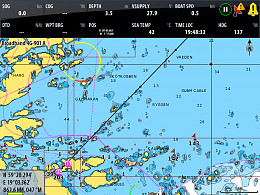
So first, the plotter. These are Navionics Platinum or Gold charts. The plotter just got its software update which gives me the great feature, which you will see in these shots, of showing unsafe water with a field of red dots.
The rhumb line from the Aaland Islands to Sandhamn:
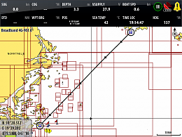
There's no detail at all at this zoom level, so of course it would be a big mistake to think that you could sail across this.
The little chart rectangles showing that there is a detailed chart for a little area tells you that this is not open sea -- a hugely helpful hint which I used all the time planning on this plotter. Surely we could have better symbols than that.
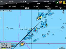
This is the last 15 miles:
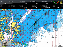
Note that even at this zoom level, you can't tell at all where the safe water is -- it's all red-spotted dangerous water.
Only at this zoom level do you have partial useful detail.
But you also didn't see the TSS:
 18
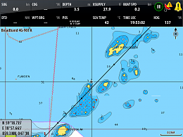
Even at this zoom level:
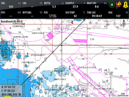
Zooming in further at the end of the route:
 20
We see that even some areas which look like safe water, even at a rather high zoom level:
 21
Is actually all red spots, i.e. dangerous water:
 22
I think that was actually a mistake in the chart layers -- shouldn't have displayed like that -- should have been red spots at the lower zoom level as well.
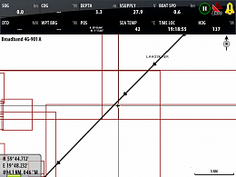
I actually planned this passage using this plotter. I didn't have paper for this particular area. Can't remember why I couldn't use OpenCPN. It was not impossible on the plotter, but it was really extremely inconvenient. With such a profound difference in the level of detail at different zoom levels, you get extremely lost zooming in and out -- really hard to maintain orientation.
I had to figure it out painstakingly, one area at a time, dropping waypoints to give me clues to see at lower zoom levels.
I started at the destination, finding the optimum way to come in from sea. There is a Recommended Route, where the ship channel comes out at Revensgrundet, but that takes you many miles out of your way, so it's worthwhile picking a path through the rocks. But which way? There are a million variants. In the event, I came in N of Horssten, passing N of Gubbarna, then Hogskar, but this was certainly not the most efficient or safe route -- it was just what I managed to do in the time I had.
And this was not particularly hard, by Baltic standards. I chose it only because it's easy to show the different effects.
I've looked at this just now in OpenCPN with CM93. There is much more useful detail here -- for example, the TSS is visible even at lower zoom level than you need to see the whole route on one screen.
I also like the way the doubtful areas of complex water are shaded in gray -- a very useful warning!! Showing that there is too much detail to show, and you'd better zoom in. This greying out goes away when you get to a zoom level adequate for basic understanding. It's much better than how the Navionics chart is presented on the Zeus. On the other hand, the CM93 has much less detail in some places, at high zoom levels. One other fun fact -- a lot of the lack of detail is because of lack of hydrography. There simply aren't soundings everywhere in this part of the world. Which makes it all much harder. I hit a rock in Finland in a spot which was plain blue on the chart (in both Navionics and CM93), looking for all the world like safe water. In another place, I saw a huge rock awash in a spot which should have had 10 meters of water or something.
I will post more -- from INavX and from OpenCPN -- as I have time.
|
|
|
|
|
04-02-2015, 14:21
|
#84
|
|
Registered User
Join Date: Oct 2011
Boat: Valiant 42
Posts: 6,008
|
Re: The Electronic Charting "Zoom Problem"
Quote:
Originally Posted by exMaggieDrum
Correction: the quote I am responding to is not this one, but rather #78 from transmitterdan.
I've been reading all this and when someone says "over-zoomed" I knew there was a problem. I think the big problem is when you are "under-zoomed" since many hazards that are shown in the detailed (zoomed in) charts do show those hazards. Which is why you need to zoom in to the see the smallest hazards that can ruin your day. Which is why under-zoomed route planning can result in catastrophe.
If I have this wrong then some definitions are in order. Using the terms "large-scale" and "small-scale" have also led to many misunderstandings.
|
I think "large scale" and "small scale" have a universally understood meaning in paper charts. They mean the same thing in digital cartography. And yes, they often get switched by people. I have done it many times, probably in this thread. Here is an accepted explanation of what the terms mean:
Types of Scales
Synopsis: Small scale has less detail. Large scale has more detail.
If a route is planned (or reviewed) at the incorrect scale that is not the fault of the machine. That's a lack of training or diligence. My view is that forcing the software to take care of untrained or lazy people is a futile exercise.
Trying to improve the software for use by trained and diligent sailors is a good thing. Unfortunately the various software vendors can't (or don't want to) agree on any best practices so there is a great lack of uniformity in the presentation of vector charts. I think this is a bigger problem than underzooming (is that a word?). Recreational plotter vendors have created a hodge podge of good ideas but not all of them are in one system and many of the ideas are incompatible with one another.
One solution would be to create standards of chart presentation and then require vendors to adhere to the standards. ECDIS has such standards of presentation I believe. But it seems unlikely recreational systems will adopt strict standards of presentation. That is unfortunate and if we want to rail on about something that might be a more fruitful line of inquiry as they say.
|
|
|
|
|
04-02-2015, 14:34
|
#85
|
|
Registered User
Join Date: Jan 2011
Posts: 670
|
Re: The Electronic Charting "Zoom Problem"
Quote:
Originally Posted by Dockhead
So first, the plotter. These are Navionics Platinum or Gold charts...and on....and on.....
|
TMI!!!!!!!!!!
You really lost me here. You post a bunch of screenshots from a commercial turnkey plotter, commenting how much better OpenCPN does it. So what's the problem? What are you asking for? Do you want automatic route plotting that will avoid obstacles? I wouldn't ever trust it. Just having that feature is a potential liability to the programmers, since someone who misuses it and runs aground will just argue, "How was I supposed to know any better?" (Sound familiar?)
Do you want full detail in all charts no matter how far out you're zoomed? Then the obstacles and depth soundings are going to shrink to the size of a pixel, and be so close together that you can't make them out. That's why virtually all chartplotters will hide things when you're zoomed way out. They need to de-clutter things, and that means hiding some stuff. And much of that hiding is done by the chart itself - the lower resolution charts don't contain it, so the chartplotter program doesn't show it. So you're asking the program to do something that it can't.
If you have not stepped through your entire route with the most detailed chart available at each point of the route, then you're taking unnecessary risk. OpenCPN has the piano keys at the bottom of the windows, with the most detailed chart at the left. So you just zoom in and pan along your entire route, making sure that the leftmost piano key is selected as you pan. Then you know you're seeing the most detailed view you possibly can.
Every new feature that is added to OpenCPN can lead to unwanted complexity and unexpected difficulties. Just look at some of the beta threads on manual chart rotation. It became very complicated very fast, and Dave ultimately took it out (with a backdoor way to reactivate the feature for the true hard-core users) because the issues were not worth the trouble for the few people who were going to use it.
I contend that your proposed change would be even worse. If the user is too unsophisticated to realize that he should zoom in to see the most detailed view of obstacles, there is no way that he will figure out the complexities of the feature that you are proposing. I can just imagine the documentation running to 20+ pages - and you still will never be confident until you view each segment of your route with the most detailed chart.
It seems that some people have mentioned plugins that may do some of what you want. That's great! From the complicated way you've described the problem, I suggest leaving the capability in the plugin, because it's too complicated to implement and document in the core program.
Quote:
Originally Posted by transmitterdan
...One solution would be to create standards of chart presentation and then require vendors to adhere to the standards. ECDIS has such standards of presentation I believe. But it seems unlikely recreational systems will adopt strict standards of presentation...
|
OpenCPN is developed to ECDIS standards. Do some searching and you'll see dozens of hits.
|
|
|
|
|
04-02-2015, 15:00
|
#86
|
|
Moderator
Join Date: Mar 2009
Location: Denmark (Winter), Helsinki (Summer); Cruising the Baltic Sea this year!
Boat: Cutter-Rigged Moody 54
Posts: 33,839
|
Re: The Electronic Charting "Zoom Problem"
Quote:
Originally Posted by RhythmDoctor
TMI!!!!!!!!!!
You really lost me here. You post a bunch of screenshots from a commercial turnkey plotter, commenting how much better OpenCPN does it. So what's the problem? What are you asking for? Do you want automatic route plotting that will avoid obstacles? I wouldn't ever trust it. Just having that feature is a potential liability to the programmers, since someone who misuses it and runs aground will just argue, "How was I supposed to know any better?" (Sound familiar?)
Do you want full detail in all charts no matter how far out you're zoomed? Then the obstacles and depth soundings are going to shrink to the size of a pixel, and be so close together that you can't make them out. That's why virtually all chartplotters will hide things when you're zoomed way out. They need to de-clutter things, and that means hiding some stuff. And much of that hiding is done by the chart itself - the lower resolution charts don't contain it, so the chartplotter program doesn't show it. So you're asking the program to do something that it can't.
If you have not stepped through your entire route with the most detailed chart available at each point of the route, then you're taking unnecessary risk. OpenCPN has the piano keys at the bottom of the windows, with the most detailed chart at the left. So you just zoom in and pan along your entire route, making sure that the leftmost piano key is selected as you pan. Then you know you're seeing the most detailed view you possibly can.
Every new feature that is added to OpenCPN can lead to unwanted complexity and unexpected difficulties. Just look at some of the beta threads on manual chart rotation. It became very complicated very fast, and Dave ultimately took it out (with a backdoor way to reactivate the feature for the true hard-core users) because the issues were not worth the trouble for the few people who were going to use it.
I contend that your proposed change would be even worse. If the user is too unsophisticated to realize that he should zoom in to see the most detailed view of obstacles, there is no way that he will figure out the complexities of the feature that you are proposing. I can just imagine the documentation running to 20+ pages - and you still will never be confident until you view each segment of your route with the most detailed chart.
It seems that some people have mentioned plugins that may do some of what you want. That's great! From the complicated way you've described the problem, I suggest leaving the capability in the plugin, because it's too complicated to implement and document in the core program.
OpenCPN is developed to ECDIS standards. Do some searching and you'll see dozens of hits. |
All of these questions are answered in the thread.
I will over the next days post screen shots from INavX, and finally from OpenCPN. That is to give a full overview of the question with a comparison of how it's dealt with in different applications.
I say one more time -- I am not, personally, interested in any automatic tool. I am interested in tools which will make it easier and more efficient and less risky to deal with situations such as the one shown in the screen shots above.
I am not a software developer myself and don't know how easy or hard any of this is. It's up to the OpenCPN developers themselves to decide whether any of this is worth acting on or not.
As to this: "Do you want full detail in all charts no matter how far out you're zoomed? Then the obstacles and depth soundings are going to shrink to the size of a pixel, and be so close together that you can't make them out. That's why virtually all chartplotters will hide things when you're zoomed way out." That is the essence of the problem, and if you read the thread you'll see how we've approached it. It's the process of decluttering itself which causes the problem. But different monitors have vastly different capabilities -- from my plotters 8" SVGA screen to my laptop's HD screen to the 32" screen I have which is 4x HD or whatever it is. So one of the things I'm suggesting, which I think contrary to what you are writing here, will be extremely simple to implement and document, is to make it possible to increase the level of detail shown relative to the zoom level, so that when using large high resolution screens, you can get enough detail to do effective planning. I think OpenCPN already has a rudiment of such capability, with its "Chart Zoom/Scale Weighting" slider. In fact, depending on how that works, maybe all that is needed on this particular issue is to expand the sliding scale on that control. Why will that present any extra challenge to the users, than what already exists? But again -- all of this is just a suggestion -- the developers will decide.
|
|
|
|
|
04-02-2015, 15:02
|
#87
|
|
Registered User
Join Date: Jan 2005
Location: On board
Boat: Van de Stadt 50'
Posts: 1,406
|
Re: The Electronic Charting "Zoom Problem"
The old "CMap" software used to virtually sail a planned route and advise of all near dangers. One ECDIS called Transas does this. Passage planning on OpenCPN is a doddle.
Paper lovers should get used to E-Charts as they will become the only way charts are provided (for many good reasons.) Paper lovers will just have to buy a large format plotter (not a chart-plotter, but a plotter) Where they can use OpenCPN to print the charts and then sharpen their pencils and polish their smiles and amuse themselves playing games for a while (Apologies to Roger Waters)
|
|
|
|
|
04-02-2015, 15:36
|
#88
|
|
Moderator
Join Date: Mar 2009
Location: Denmark (Winter), Helsinki (Summer); Cruising the Baltic Sea this year!
Boat: Cutter-Rigged Moody 54
Posts: 33,839
|
Re: The Electronic Charting "Zoom Problem"
The OpenCPN documentation contains a more articulate description of the problem, than what I managed:
"Using CM93 in OpenCPN
It all starts with passage planning. The bottom line is: Don't trust CM93. Always check with other reliable sources, meaning, for example, Raster charts (paper charts) Pilot Books, or ENC charts, not another privately issued vector chart, with similar problems ( for example Navionics).. . .
"The reason is the very poor graphical representation in small scale charts, of reefs,small islands and other dangers."
Exactly. And one of my suggestions is that we could use larger scale charts, quilted together, at lower zoom settings, if we have a higher resolution monitor. Just need to extend that slider, probably.
The other suggestion is to create some kind of abstract graphical representation of dangers present in underlying larger scale charts, when we are looking at the smaller scale charts.
It's for the developers to decide whether these suggestions have any merit or not. I am merely a user.
|
|
|
|
|
04-02-2015, 16:07
|
#89
|
|
Registered User
Join Date: Oct 2005
Location: Presently on US East Coast
Boat: Manta 40 "Reach"
Posts: 10,108
|
Re: The Electronic Charting "Zoom Problem"
So this is all a chart choice problem? Vote with your wallet. Don't get charts that do not have the detail or functionality you desire.
Mark
__________________
www.svreach.com
You do not need a parachute to skydive. You only need a parachute to skydive twice.
|
|
|
|
|
04-02-2015, 16:29
|
#90
|
|
Moderator
Join Date: Mar 2009
Location: Denmark (Winter), Helsinki (Summer); Cruising the Baltic Sea this year!
Boat: Cutter-Rigged Moody 54
Posts: 33,839
|
Re: The Electronic Charting "Zoom Problem"
Quote:
Originally Posted by colemj
So this is all a chart choice problem? Vote with your wallet. Don't get charts that do not have the detail or functionality you desire.
Mark
|
Sure, if you want to look at it that way -- it's the choice of ordinary vector charts like we all use (Navionics is even worse, according to OpenCPN documentation) versus paper or pilot books or ENC charts -- according to the OpenCPN documentation. With their "poor graphic representation in small scale charts of reefs,small islands and other dangers." That's the OpenCPN authors talking about the vector charts on your plotter, and on mine. Kind of what I have been talking about all this time.
So we can make a different chart choice, like some on here do -- namely paper. I don't know where to buy ENC charts, and I'm guessing the cost is prohibitive. Raster charts are immune to this problem since they only have a single layer, but bring their own problems. Might be worth trying just for planning purposes -- NV sell them for my cruising area, albeit at a quite high cost -- about 400 euros or nearly $500 just for Finnish waters.
Or we can try to use what we have -- the commercial vector charts used by 99% of cruisers -- in a better way.
|
|
|
|
|
|
| Thread Tools |
Search this Thread |
|
|
|
| Display Modes |
Rate This Thread |
 Linear Mode Linear Mode
|
|
 Posting Rules
|
You may not post new threads
You may not post replies
You may not post attachments
You may not edit your posts
HTML code is Off
|
|
|
|
Advertise Here

 Recent Discussions Recent Discussions |
|
|
|
|
|
|
|
|
|
|
|
|
|
|
|
|
|
|
|
|
|
|
|
|
|
Vendor Spotlight |
|
|
|
|
|
|
|
|
|


