The CM93 directory contains a number of subdirectories named from
"00300000" to "04501020". These folders cover a geographical area of
40 deg x 40 deg. The first four numbers describes the latitude and the last the longitude of the SW corner of the area covered.
The key to understanding the numbers is to realize that CM93's coordinate system of the world starts at the South Pole or to be exact at lat -90 long 0 and from there proceeds North a East with a factor of 3 for each degree of lat and long.
The tile 00300000 hence covers the lat from 90S + 0030:3 = 80S to
40S and longitude from 0E to 40E.
Looking at 04501020 it brakes down to lat 90S + 0450:3 = 60N and long 1020:3 = 340E => 20W. So we have he SW corner at 60N and 20W .
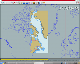
This is the tile 03900840 with the SW corner at 40N x 80W i loaded all by itself.
Each of these sub-folders in turn contains folders with the individual
charts. Ordered in scale from smalest to largest they are Z,A,B,C,D,E,F and G. Where Z is an overview chart and G is a harbor plan. Note that, generally, not all of these are present in each subdirectory.
Z covers 40 x 40 deg and
OpenCPN typically uses 1:3.000.000 scale
A covers 20 x 20 deg and
OpenCPN typically uses 1:1.000.000 scale
B covers 10 x 10 deg and OpenCPN typically uses 1:200.000 scale
down to
..
G covers 20' x 20' and OpenCPN typically uses 1:3500 scale.
This info should make it possible for users to load the part of CM93 that they are interested in. For full
documentation see the OpenCPN source code or ask Dave who must know the nitty gritty details.

Thomas