 |
|
 28-12-2009, 15:37
|
#31
|
|
Registered User

Join Date: Dec 2009
Location: Ibiza, Spain
Boat: At the moment, Chrome on Ubuntu I'm afraid, but I take out lots of little ones
Posts: 59
|
My first post here. First of all I'd like to say how glad I am to have found OpenCPN, I have a dual-boot WinXP/Ubuntu laptop and was _only_ booting Windows to run Maptech CNPro; nice piece of software, I must say, but this is way good enough for me.
Oh I do have a wishlist for opencpn but as it is, the advantage of not having to boot XP far outweighs any little bells and whistles the other software has.
I'll leave the wishlist for some other time, I have a question on _charts_ I'd like to submit to such knowledgeable people: my favorite chart of this area (the Balearic Islands) is not read by opencpn. It's made up of lots of little bits, I think they're called tiles.
Does anyone know how I can reconstruct it to a file that's readable by opencpn, or if it's planned to have it read tiles in the near future?
I tried the Maptiler that Manimaul mentions, with not much luck for the moment.
I'll also be reading this with great interest as I have lots of scanned images of good charts of this area and would love to be able to turn them into usable electronic charts.
Thanks again for writing opencpn.
|

|

|
|
28-12-2009, 15:48
|
#32
|
|
Registered User
Join Date: Sep 2007
Location: Almería, ES
Boat: Chiquita 46 - Libertalia
Posts: 1,558
|
What's the actual format of your Baleriac Isles charts? What do the files look like?
|
|
|
|
|
28-12-2009, 15:48
|
#33
|
|
Obsfucator, Second Class
Join Date: Feb 2008
Location: Southeast USA.
Boat: 1982 Sea Ray SRV360
Posts: 1,745
|
Quote:
Originally Posted by Don B. Cilly

... I have a question on _charts_ I'd like to submit to such knowledgeable people: my favorite chart of this area (the Balearic Islands) is not read by opencpn. It's made up of lots of little bits, I think they're called tiles.
Does anyone know how I can reconstruct it to a file that's readable by opencpn, or if it's planned to have it read tiles in the near future?
I tried the Maptiler that Manimaul mentions, with not much luck for the moment...
|
Check out the mc2bsbh - MapCal template to BSB template Conversion thread for converting scanned charts to a format that OpenCPN can read.
How you get tiled charts converted to a plain raster image is another matter...
-dan
|
|
|
|
|
28-12-2009, 16:03
|
#34
|
|
Registered User
Join Date: Dec 2009
Location: Ibiza, Spain
Boat: At the moment, Chrome on Ubuntu I'm afraid, but I take out lots of little ones
Posts: 59
|
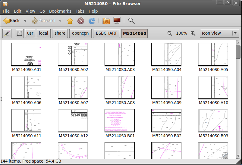
>What do the files look like?
They look like this:
|
|
|
|
|
28-12-2009, 16:06
|
#35
|
|
Registered User
Join Date: Dec 2009
Location: Ibiza, Spain
Boat: At the moment, Chrome on Ubuntu I'm afraid, but I take out lots of little ones
Posts: 59
|
>Check out the MapCal template to BSB template Conversion
Thanks. That will take me a while, but I'll look into it tomorrow. It's 1am here...
|
|
|
|
|
28-12-2009, 17:09
|
#36
|
|
Obsfucator, Second Class
Join Date: Feb 2008
Location: Southeast USA.
Boat: 1982 Sea Ray SRV360
Posts: 1,745
|
Quote:
Originally Posted by Don B. Cilly
>What do the files look like?
They look like this:
|
Yikes!
Yep, that could be an issue. Maybe someone has an idea of a utility that can combine those into a single image (or a few images) that isn't too labor intensive.
mc2bsbh won't help you with that until you get them combined.
-dan
|
|
|
|
|
28-12-2009, 17:46
|
#37
|
|
Marine Service Provider
Join Date: Mar 2008
Posts: 7,394
|
Maptech charts
I think these are very early (early 90s) Maptech raster charts. They are tiff files, I think, and the georef is contained in a header file of some sort.
Blast from the past.....
Should be possible, if laborious, to combine the tiffs into one big tiff, manually decode the header file, and proceed from there.....
Dave
|
|
|
|
|
29-12-2009, 02:06
|
#38
|
|
Registered User
Join Date: Dec 2009
Location: Ibiza, Spain
Boat: At the moment, Chrome on Ubuntu I'm afraid, but I take out lots of little ones
Posts: 59
|
>I think these are very early (early 90s) Maptech raster charts.
Exactly. It's a 1993 Defense Mapping Agency chart.
I have a sort of a crush on it because even though it's old and quite ugly, it's the one chart of this area that's perfectly calibrated, it gives me the exact spot in the marina, so if I really want some precision I go to that. All other charts range from slightly off to quite a bit off.
>They are tiff files, I think, and the georef is contained in a header file of some sort
They're actually PCX, and the georef is indeed in a separate file.
I think the idea was, in those days, processor and memory were scarce, loading one little tile at a time as the boat moved made it all faster.
The fact is, I have over 9000 (a figure of speech  charts like that, most of them quite good. And it's bad news indeed that it seems nothing much can be done with them, short of manually pasting the tiles together (that one chart, as you can see, has 144 tiles) and recalibrating it.
I am going to look into the mc2bsbh thing anyway, as it seems that if I can recalibrate my other ones well enough, well, that's one problem solved, but...
... if I have all those charts in that format, chances are a lot of people out there will have those too. Wouldn't it be worth it to look into making opencpn read the format?
With a bit of luck, the code will be simple enough, the header file comes with the chart...
|
|
|
|
|
29-12-2009, 03:10
|
#39
|
|
Registered User
Join Date: Sep 2003
Location: Ubatuba,SP,Brazil (Ex Norway)
Boat: (Ex) Alu. 60' yacht-"Eight Bells"
Posts: 2,731
|
Don B. Cilly..
I have a good,.kap calibrated chart of Mallorca etc. Could it be the same one you have? Let me have your e-mail and I'll send it to you.
__________________
"And all I ask is a tall ship and a star to steer her by."
|
|
|
|
|
29-12-2009, 10:03
|
#40
|
|
Registered User
Join Date: Dec 2009
Location: Ibiza, Spain
Boat: At the moment, Chrome on Ubuntu I'm afraid, but I take out lots of little ones
Posts: 59
|
Quote:
Originally Posted by sinbad7
I have a good,.kap calibrated chart of Mallorca etc. Could it be the same one you have? Let me have your e-mail and I'll send it to you.
|
Wow, thanks.
It's not the same I have and it doesn't look like any I have. I have replied to your mail, with the tiled pieces you offered to have a look at, but as I said there, if it's too much trouble, don't bother, if this one is accurate enough it's all I need.
If on the other hand you have a reasonably simple way of reconstructing that sort of chart and you'd like to share it, I'm sure quite a few people will find it interesting.
Google seems to index this forum almost instantly, I found my own post on it last night barely ten minutes after i wrote it.
|
|
|
|
|
29-12-2009, 11:08
|
#41
|
|
Registered User
Join Date: Sep 2003
Location: Ubatuba,SP,Brazil (Ex Norway)
Boat: (Ex) Alu. 60' yacht-"Eight Bells"
Posts: 2,731
|
Don B. Cilly..
To convert your tiles into a suitable chart size prior to conversion I suggest the following:
1.Rename all the files to a .pcx appendage.
2. Download and use 'S_Merge' to assemble the tiles to one map
When you have a suitable chart size,let me know and we'll take it from there.
__________________
"And all I ask is a tall ship and a star to steer her by."
|
|
|
|
|
29-12-2009, 12:25
|
#42
|
|
Registered User
Join Date: Sep 2003
Location: Ubatuba,SP,Brazil (Ex Norway)
Boat: (Ex) Alu. 60' yacht-"Eight Bells"
Posts: 2,731
|
I had a go at stiching up the tiles but as the trial 'S_Merge' prog is limited to 8 tiles at the time,the sample attached contains just 16 tiles covering the top left of the chart.
The merged chart also contains lots of overprints but at least gives you the idea.
__________________
"And all I ask is a tall ship and a star to steer her by."
|
|
|
|
|
30-12-2009, 05:40
|
#43
|
|
Registered User
Join Date: Sep 2003
Location: Ubatuba,SP,Brazil (Ex Norway)
Boat: (Ex) Alu. 60' yacht-"Eight Bells"
Posts: 2,731
|
Don B. Cilly
I have merged your tiles covering the island of Ibiza and surrounds and converted to .kap format. As we already have a good map of Mallorca,I concentrated on Ibiza. You can download it from my 4Store area.
__________________
"And all I ask is a tall ship and a star to steer her by."
|
|
|
|
|
30-12-2009, 10:33
|
#44
|
|
Registered User
Join Date: Dec 2009
Location: Ibiza, Spain
Boat: At the moment, Chrome on Ubuntu I'm afraid, but I take out lots of little ones
Posts: 59
|
Wow, Sinbad, you're amazing. I got the chart, thanks.
I tried the Thanks button too but it says, "You must spread some Thanks around before giving it to sinbad7 again.", which is a bit odd since I really had you to thank again.
I wonder how you did it.. I had a look at that software but I'm not going to buy it just yet, I then tried getting something called nip2 which is supposed to do things like that but it's got a serious dependency problem and is not installable (first time I had to give up on an Ubuntu install)...
The chart looks great, but... I'm sorry to say that it's got two little problems, I'm sure they're solvable.
One, the "preview" shows up blank in opencpn. I noticed it did that with the plans you sent me that had no soundings.
Two, the calibration is, I'm afraid, way off, one point I tried was off by some 12 miles in lat and 5 in lon.
Still, I _am_ going to look into that calibration stuff in this here forum when I have a quiet moment, so I guess this will be the place to start.
Thanks again
D.
|
|
|
|
|
30-12-2009, 11:22
|
#45
|
|
Registered User
Join Date: Sep 2003
Location: Ubatuba,SP,Brazil (Ex Norway)
Boat: (Ex) Alu. 60' yacht-"Eight Bells"
Posts: 2,731
|
Don B. Cilly
Not sure what you mean the chart does not show up in 'preview'?
If you mean the dark red chart outline,make sure you have ticked the 'Show Chart outlines' in the toolbox.
Could you please tell me EXACTLY where you found the wrong calibration..
Tore
__________________
"And all I ask is a tall ship and a star to steer her by."
|
|
|
|
|
|
| Thread Tools |
Search this Thread |
|
|
|
| Display Modes |
Rate This Thread |
 Linear Mode Linear Mode
|
|
 Posting Rules
|
You may not post new threads
You may not post replies
You may not post attachments
You may not edit your posts
HTML code is Off
|
|
|
|
Advertise Here

 Recent Discussions Recent Discussions |
|
|
|
|
|
|
|
|
|
|
|
|
|
|
|
|
|
|
|
|
|
|
|
|
|
Vendor Spotlight |
|
|
|
|
|
|
|
|
|


