 |
|
 29-08-2011, 13:21
|
#481
|
|
Registered User

Join Date: Nov 2004
Location: Davao, Philippines
Posts: 1,776
|
Re: Charts II: NGA - 2700 Charts
PS: I wonder what they did with the cemetery? It was actually where the El Cid resort next to the marina is now. We spent 5 weeks there in 2010. The marina is great and you get to use all the resort facilities, but the hot tub may be haunted.
__________________
Paul,
" One moment you are running along, the next you are no more." Dean Spanley
|

|

|
|
29-08-2011, 15:49
|
#483
|
|
Registered User
Join Date: Sep 2003
Location: Ubatuba,SP,Brazil (Ex Norway)
Boat: (Ex) Alu. 60' yacht-"Eight Bells"
Posts: 2,731
|
Re: Charts II: NGA - 2700 Charts
I am not managing to activate the NGA download page any more. Has the URL been changed?
This is the address I used earlier: http://opencpn.info/en/nga-charts-status-misc
Tore
__________________
"And all I ask is a tall ship and a star to steer her by."
|
|
|
|
|
30-08-2011, 11:41
|
#484
|
|
Registered User
Join Date: Jul 2009
Location: South Carolina
Boat: 40' Jeanneau
Posts: 492
|
Re: Charts II: NGA - 2700 Charts
Cagney:
Would your warning apply to a chart like #25570? The title block says it is WGS, but it does not specify WGS 84.
|
|
|
|
|
30-08-2011, 13:10
|
#485
|
|
Registered User
Join Date: Dec 2005
Location: Helsingborg
Boat: Dufour 35
Posts: 3,891
|
Re: Charts II: NGA - 2700 Charts
No! I'm only talking about charts with a note similar to this
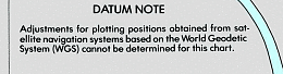
My interpretation of this is that the chart is so "warped" that it is not possible to determine a single vector to bring the whole chart in agreement with WGS.
I agree that with the word "WGS", it is not always clear if WGS72 or WGS84 is referred to. In practice this not that important as the difference is very small.
Thomas
|
|
|
|
|
31-08-2011, 07:03
|
#486
|
|
Registered User
Join Date: Jul 2009
Location: South Carolina
Boat: 40' Jeanneau
Posts: 492
|
Re: Charts II: NGA - 2700 Charts
I see the new web-based calibration system when I log in to the chart storage website. It looks cool!
I'm not sure how to put the NE and SW pixel coordinates in, though. Will we need to download the whole .jpg file and use a graphics program to find those? Or is there more to come?
I'm guessing it's too soon for us to start inputting data?
|
|
|
|
|
31-08-2011, 08:11
|
#487
|
|
Registered User
Join Date: Feb 2010
Location: Tierra del Fuego
Boat: Phantom 19
Posts: 6,207
|
Re: Charts II: NGA - 2700 Charts
Tia Bu...
The website calibration tool is finished for now and able to collect the input and produce KAPs for the rectangular charts. Many thanks go to Netsurfer for the tremendous amount of work he's done on it.
The pixel coordinates are separate from the lat/lon and we are trying to collect all the 4 of them if possible to do some magick with the geometry of the images and detect erroneous input. You can find them on the "tab" under the NE and SW coordinates.
More instructions to come when I have a while to write them - now I'm tuning the server-side generation routines.
If you have some time, give it a try and let me know what's not clear from the tooltips on the calibration page and if you find any glitches.
Any input made will be very useful for us to prioritize future enhancements to the tool.
Pavel
|
|
|
|
|
31-08-2011, 09:08
|
#488
|
|
Registered User
Join Date: Jul 2009
Location: South Carolina
Boat: 40' Jeanneau
Posts: 492
|
Re: Charts II: NGA - 2700 Charts
Thanks, Nohal. What an impressive effort!
I tried to input the information for Chart 14018 and encountered the following problems:
1- Chart Type. Where would I get this information? I couldn't find it printed on the chart.
2- Datum: The chart simply says the datum is WGS. There is no number (72 or 84) after that. How should this be entered on your form?
3- Sounding Datum: I could find no sounding datum given for this chart. How should we handle that on the form?
4- Calibration. A left mouse click and dragging does not move the selection square. I tried and tried. Sometimes the square would drag with a little "no parking" symbol over it. Sometimes the entire image simply turned blue. When I tried using other zoom levels, the simplest mouse movement simply made the image disappear, and nothing would make it reappear. I'm using Mozilla Firefox. Should I use a different browser?
I hope this feedback helps. I did not save any changes to the form.
This is exciting!
|
|
|
|
|
31-08-2011, 09:38
|
#489
|
|
Registered User
Join Date: Feb 2010
Location: Tierra del Fuego
Boat: Phantom 19
Posts: 6,207
|
Re: Charts II: NGA - 2700 Charts
Good questions 
Quote:
Originally Posted by Tia Bu

1- Chart Type. Where would I get this information? I couldn't find it printed on the chart.
|
This is probably never to be found on the chart - it is chart categorization used in *.BSB files as defined by the BSB standard (which we don't have, so I collected the possible values from the official Maptech produced charts I've had access to)
Use the "best guess" method for now or leave it untouched - as far as I can tell it's not used for anything crucial by the chartplotters, if used at all.
Quote:
|
2- Datum: The chart simply says the datum is WGS. There is no number (72 or 84) after that. How should this be entered on your form?
|
The difference is very minor between those two ellipsoids. When the datum note (on this one in the SE corner) says no mods needed to plot the GPS coordinates, I choose WGS84
Quote:
|
3- Sounding Datum: I could find no sounding datum given for this chart. How should we handle that on the form?
|
My best for this chart would probably be "unknown" - the last option in the list.
Quote:
|
4- Calibration. A left mouse click and dragging does not move the selection square. I tried and tried. Sometimes the square would drag with a little "no parking" symbol over it. Sometimes the entire image simply turned blue. When I tried using other zoom levels, the simplest mouse movement simply made the image disappear, and nothing would make it reappear. I'm using Mozilla Firefox. Should I use a different browser?
|
Which version of FF are you on?
We tested the function extensively with recent versions of Firefox and Chrome on Windows and a little with IE9 on Windows and Firefox 3 on Ubuntu. All seemed to work.
The basic "trick" is, that in the left part, you have to drag the small red square, initially in the top left corner, while in the right, zoomed in part, you drag the image under the red cross.
When something goes wrong, use the respective reset button next to the corner coordinates above the images to get to the initial state.
I can confirm a bit unpredictable behavior on 1:2 and 1:1, when you try to drag the image and not the red square in the left part.
If the problems persist, let me know and we will keep investigating.
Quote:
|
I hope this feedback helps. I did not save any changes to the form.
|
Of course it does! Many thanks for it.
Pavel
|
|
|
|
|
31-08-2011, 09:44
|
#490
|
|
Registered User
Join Date: Dec 2005
Location: Helsingborg
Boat: Dufour 35
Posts: 3,891
|
Re: Charts II: NGA - 2700 Charts
Quote:
Originally Posted by Tia Bu
Thanks, Nohal. What an impressive effort!
I tried to input the information for Chart 14018 and encountered the following problems:
1- Chart Type. Where would I get this information? I couldn't find it printed on the chart.
2- Datum: The chart simply says the datum is WGS. There is no number (72 or 84) after that. How should this be entered on your form?
3- Sounding Datum: I could find no sounding datum given for this chart. How should we handle that on the form?
4- Calibration. A left mouse click and dragging does not move the selection square. I tried and tried. Sometimes the square would drag with a little "no parking" symbol over it. Sometimes the entire image simply turned blue. When I tried using other zoom levels, the simplest mouse movement simply made the image disappear, and nothing would make it reappear. I'm using Mozilla Firefox. Should I use a different browser?
I hope this feedback helps. I did not save any changes to the form.
This is exciting!
|
Nohal has just answered but my response fills in some details.
Netsurfer is the guy behind the very cool web interface and Nohal is responsible for smart number crunching and back-end wizardry.
Your questions:
1 Look in Bowditch, or an other text book, how charts are categorized. International is if it has an INT XXX number, and is part of the International series of charts. These are generally small scale charts, but costal charts are in the pipeline.
2 From Bowditch:
Quote:
Further refinement of WGS 72 resulted in the new World
Geodetic System of 1984 (WGS 84), now referred to as
simply WGS. For surface navigation, WGS 60, 66, 72 and the
new WGS 84 are essentially the same, so that positions
computed on any WGS coordinates can be plotted directly on
the others without correction.
|
So I suggest that if the chart is issued 1985 or later WGS means WGS 84. I it is issued earlier it means WGS 72.
3 Choose "unknown".
4 I have no problems on Mozilla. It does work, but some instruction are probably necessary. I think hat Nohal is working on that.
Thomas
|
|
|
|
|
31-08-2011, 09:49
|
#491
|
|
Registered User
Join Date: Feb 2010
Location: Tierra del Fuego
Boat: Phantom 19
Posts: 6,207
|
Re: Charts II: NGA - 2700 Charts
And one more important note to the workflow:
When you save your calibration, it's picked up by a backend process on another server in 0-5 minutes, checked to meet the criteria for creating the KAP and if considered OK, the KAP is generated.
Depending on the current load on the server and the size of the respective chart, the creation takes another 1-5 minutes. After that, on next load of the chart list for the respective region (eg. NGA Charts Status Region 1 at OpenCPN.info (English)) the link to the generated KAP will appear.
If you will check whether the chart is OK and it will not be for whichever reason, let me know - this process is in very early stage of the development and I'm sure it's not perfect. The more glitches we discover early, the better. The same applies for any chart you think should be generated and isn't...
For now the conditions are simple and strict - the chart has to have all the 4 corners calibrated.
Thanks a lot
Pavel
|
|
|
|
|
31-08-2011, 10:03
|
#492
|
|
Registered User
Join Date: Dec 2005
Location: Helsingborg
Boat: Dufour 35
Posts: 3,891
|
Re: Charts II: NGA - 2700 Charts
Nohal
I just did 21017 which is an interesting chart, because there is no geodetic datum given and a note says that it is not possible to give any corrections to bring it to WGS.
This case isn't exactly covered by the web form, but my "solution" was accepted and a kap produced that fits fairly well with CM93, where the meta data refers to WGS 84! OpenCPN of course treat the chart as if it is WGS 84.
The west coast of Mexico is well known for problems with plotting GPS positions directly on existing, very old charts.
21017 is not at all a OMEGA chart as he title says!!
Thomas
|
|
|
|
|
31-08-2011, 10:45
|
#493
|
|
Registered User
Join Date: Feb 2010
Location: Tierra del Fuego
Boat: Phantom 19
Posts: 6,207
|
Re: Charts II: NGA - 2700 Charts
Thomas,
I'm currently taking the most relaxed approach possible to refusing to produce the chart to see what the results will actually be in cases like this.
We will probably have to treat the "problematic" charts on a one-by-one basis, as for example 14380 is WGS and Mercator, but the chart note says: "Longitudes on this chart may be up to 30" less than their actual positions"
The missing definition of ellipsoid will usually not produce such a big error, so I really don't know how to handle something like this systematically...
Pavel
|
|
|
|
|
31-08-2011, 10:58
|
#494
|
|
Registered User
Join Date: Dec 2005
Location: Helsingborg
Boat: Dufour 35
Posts: 3,891
|
Re: Charts II: NGA - 2700 Charts
Quote:
Originally Posted by nohal
Thomas,
I'm currently taking the most relaxed approach possible to refusing to produce the chart to see what the results will actually be in cases like this.
We will probably have to treat the "problematic" charts on a one-by-one basis, as for example 14380 is WGS and Mercator, but the chart note says: "Longitudes on this chart may be up to 30" less than their actual positions"
The missing definition of ellipsoid will usually not produce such a big error, so I really don't know how to handle something like this systematically...
Pavel
|
Pavel
I don't think there is much we can do, except for showing the chart the way the cartographer intended. It is very difficult to second guess his reasoning.
Unless ... we use "convert" to print a more prominent warning in the margin of charts with known problems ( Only shows in single mode ), or something similar.
Thomas
|
|
|
|
|
31-08-2011, 11:42
|
#495
|
|
Registered User
Join Date: May 2011
Location: underway whenever possible
Boat: Rangeboat 39
Posts: 4,734
|
Re: Charts II: NGA - 2700 Charts
Hi,
working on the online CAL procedures a question:
on the charts the corners show seconds.decimal. The mouse tip says "digits only".
How should we handle this value? Rounding? Input without decimal dot/comma?
Tested with WindowsXP/Opera 11.50 - no problem
Hubert
|
|
|
|
|
|
| Thread Tools |
Search this Thread |
|
|
|
| Display Modes |
Rate This Thread |
 Linear Mode Linear Mode
|
|
 Posting Rules
|
You may not post new threads
You may not post replies
You may not post attachments
You may not edit your posts
HTML code is Off
|
|
|
|
Advertise Here

 Recent Discussions Recent Discussions |
|
|
|
|
|
|
|
|
|
|
|
|
|
|
|
|
|
|
|
|
|
|
|
|
|
Vendor Spotlight |
|
|
|
|
|
|
|
|
|


