 |
|
 29-06-2019, 18:13
|
#61
|
|
Registered User

Join Date: Dec 2009
Location: Bundaberg, Qld.
Posts: 2,192
|
Re: Paper Charts or Just Electronic
Quote:
Originally Posted by Jim Cate

Amusing anecdote!
Couple of years ago an Aussie navy destroyer came into Hobart and was giving tours, so we went aboard. When we got to the bridge the young officer who was guiding us waxed on about t heir fancy electronic nav systems, and how wonderful they were. But I was looking elsewhere and found a desk with a paper chart of the Derwent river, up which they had just come. And on it were penciled fixes from sightings of shore objects taken with a pelorus... every few hundred meters. I later asked him about this, and he admitted that despite the fancy modern stuff, their practice was to keep the plot by these old methods. Note that this is a wide and deep river, and the passage was in daylight. I was amused, he seemed kinda embarrassed!
Jim |
Due to a couple of 'incidents' for the time being the Australian Navy are still required to carry paper charts regardless of what electronic nav systems are fitted, there is a phasing out period for them but i don't know the time frame.....
https://www.brisbanetimes.com.au/pol...10-p508uz.html
|

|

|
|
29-06-2019, 18:24
|
#62
|
|
Moderator Emeritus

Join Date: Oct 2013
Location: Jacksonville/ out cruising
Boat: Island Packet 38
Posts: 31,351
|
Paper Charts or Just Electronic
Quote:
Originally Posted by Dockhead
Well, I don't think air navigation is quite the same -- you fly mostly straight lines, but we might have complicated paths to follow through different obstacles. |
We would fly the entire route, at night at 50. Hundred or so miles. Check points needed to be hit 0 seconds early, up to 30 sec late.
You never flew straight lines, that gave away where you were going. it was all on paper maps, later of course GPS, Nav was what made a mission a success or a failure, GPS and digital moving maps changed all of that, how could you not know where you are?
Same in a boat.
Marine navigation is a piece of cake, honestly, what gets people I think must be complacency or inaccurate charts, or they just got stupid.
When its 5,000 ft deep and you have days to go to get to anywhere Nav just isnt an issue, its really only an issue at departure and arrival.
|
|
|
|
|
29-06-2019, 18:40
|
#63
|
|
Registered User
Join Date: Dec 2009
Location: Bundaberg, Qld.
Posts: 2,192
|
Re: Paper Charts or Just Electronic
Quote:
Originally Posted by GrowleyMonster
So, not U.S. flag, then. Okay since I have only sailed on two foreign flag ships and they were before ECDIS, before GPS, even, I will concede that maybe ships registered to other countries do not all carry paper charts. However I will stick to what I said in that I have never in my entire career sailed on a ship under U.S. flag that did not carry and use paper charts even though full ECDIS is running. It simply is not done. This is not just history. I am still actively sailing. |
Understood, but respectfully just because you haven't come across them does not make it so...  https://www.dco.uscg.mil/ECDIS/
Quote:
The United States Navigation Safety Regulations in 33 CFR Part 164 require that vessels have on board corrected marine charts of the areas to be transited. These charts must be of a large enough scale and have enough detail to make safe navigation in the area possible. Similarly, International regulations for the carriage of charts and publications are outlined in regulation V/19 of the 1974 International Convention for the Safety of Life at Sea (SOLAS).
An alternative to the carriage of paper navigation charts is an Electronic Chart Display and Information System (ECDIS). ECDIS is a navigation information system which, with adequate back-up arrangements, can be accepted as complying with the chart carriage requirements in regulation V/19 of the 1974 SOLAS Convention, by displaying selected information from a system electronic navigational chart (SENC) with positional information from navigation sensors to assist the mariner in route planning and route monitoring, and by displaying additional navigation-related information.
On July 14, 2004, the US Coast Guard published a notice in the Federal Register outlining the criteria by which ECDIS could be used to meet the charts carriage requirements outlined in 33 CFR 164.33.
42192 Federal Register / Vol. 69, No. 134 / Wednesday, July 14, 2004 / Notices
“Carriage of Navigation Equipment for Ships on International Voyages”
“If a ship has an approved ECDIS installed according to chapter V, the ECDIS will be considered by the Coast Guard as meeting its nautical chart regulation in 33 CFR 164.33(a)(1), because the ECDIS meets the same navigational safety concerns as do paper nautical charts. This policy benefits the ship owner and operator by relieving them of the need to unnecessarily duplicate equipment.”
|
Also if interested look up https://www.thetvib.org/wp-content/u...ications-3.pdf
|
|
|
|
|
29-06-2019, 19:00
|
#64
|
|
Registered User
Join Date: Nov 2013
Location: Port Moresby,Papua New Guinea
Boat: FP Belize Maestro 43 and OPBs
Posts: 12,891
|
Re: Paper Charts or Just Electronic
Quote:
Originally Posted by Simi 60
I believe the latest version of opencpn also allows split screen, one side zoomed in and the other out so that takes care of the missing out on details issue that many seemed concerned about. |
Yep, very useful!
|
|
|
|
|
30-06-2019, 02:06
|
#65
|
|
Moderator
Join Date: Mar 2009
Location: Denmark (Winter), Helsinki (Summer); Cruising the Baltic Sea this year!
Boat: Cutter-Rigged Moody 54
Posts: 33,865
|
Re: Paper Charts or Just Electronic
Quote:
Originally Posted by a64pilot
. . . Marine navigation is a piece of cake, honestly, what gets people I think must be complacency or inaccurate charts, or they just got stupid.
When it’s 5,000 ft deep and you have days to go to get to anywhere Nav just isn’t an issue, it’s really only an issue at departure and arrival.
|
Well, that's what Team Vestas thought.
But 5,000 ft deep becomes a shoal in a few cables, in some places -- like where Team Vestas came to grief.
99% of the time you can just sail for days, and that makes you complacent, but that 1% can bite you if you haven't done your nav properly. It's not easy to do it properly on a small screen with vector charts.
__________________
"You sea! I resign myself to you also . . . . I guess what you mean,
I behold from the beach your crooked inviting fingers,
I believe you refuse to go back without feeling of me;
We must have a turn together . . . . I undress . . . . hurry me out of sight of the land,
Cushion me soft . . . . rock me in billowy drowse,
Dash me with amorous wet . . . . I can repay you."
Walt Whitman
|
|
|
|
|
30-06-2019, 02:13
|
#66
|
|
Moderator
Join Date: Mar 2009
Location: Denmark (Winter), Helsinki (Summer); Cruising the Baltic Sea this year!
Boat: Cutter-Rigged Moody 54
Posts: 33,865
|
Re: Paper Charts or Just Electronic
Quote:
Originally Posted by Jim Cate
Amusing anecdote!
Couple of years ago an Aussie navy destroyer came into Hobart and was giving tours, so we went aboard. When we got to the bridge the young officer who was guiding us waxed on about t heir fancy electronic nav systems, and how wonderful they were. But I was looking elsewhere and found a desk with a paper chart of the Derwent river, up which they had just come. And on it were penciled fixes from sightings of shore objects taken with a pelorus... every few hundred meters. I later asked him about this, and he admitted that despite the fancy modern stuff, their practice was to keep the plot by these old methods. Note that this is a wide and deep river, and the passage was in daylight. I was amused, he seemed kinda embarrassed!
Jim |
Well, that's damned good practice. A basic principle of good navigation (and even more, good pilotage) is to always have at least two sources for every datum upon which the safety of the vessel depends. GPS is only one source of position data.
That kind of chart work is laborious and impractical on a constant basis on a small boat, but some of us do use parallel indexes and clearing bearings and do other kinds of chart work.
I don't think it's really good practice to just religiously believe what one chart plotter tells you about your position, and the position of hazards in relation to you.
__________________
"You sea! I resign myself to you also . . . . I guess what you mean,
I behold from the beach your crooked inviting fingers,
I believe you refuse to go back without feeling of me;
We must have a turn together . . . . I undress . . . . hurry me out of sight of the land,
Cushion me soft . . . . rock me in billowy drowse,
Dash me with amorous wet . . . . I can repay you."
Walt Whitman
|
|
|
|
|
30-06-2019, 02:41
|
#67
|
|
cruiser
Join Date: Nov 2007
Location: Probably in an anchorage or a boatyard..
Boat: Ebbtide 33' steel cutter
Posts: 5,030
|
Re: Paper Charts or Just Electronic
Quote:
Originally Posted by Dockhead
Well, that's what Team Vestas thought.
But 5,000 ft deep becomes a shoal in a few cables, in some places -- like where Team Vestas came to grief.
99% of the time you can just sail for days, and that makes you complacent, but that 1% can bite you if you haven't done your nav properly. It's not easy to do it properly on a small screen with vector charts. |
Very bad example imho. Team Vestas is an example of what happens if you are really stupid, no excuse on their navigators part. It's really easy to not make such a stupid mistake, takes about 2 seconds glance on google earth to see any seamounts to avoid let alone islands /reefs. Not like the Cargados Carajos Shoals aren't known about. Good example of how even people can be idiots even when highly paid, really hard to think how anyone could have made such a glaring stupid ocean planning error - things like that leap off the page/screen weeks before when you're starting to have a look at an ocean passage. Anyone who isn't wary enough to check multiple sources then still have another quick check should stick to making sandwiches and keep away from pointing the boat. Really isn't rocket science. 
|
|
|
|
|
30-06-2019, 04:26
|
#68
|
|
Moderator Emeritus
Join Date: Oct 2013
Location: Jacksonville/ out cruising
Boat: Island Packet 38
Posts: 31,351
|
Paper Charts or Just Electronic
I wont go so far as to call them idiots, I assume they were off course and tired. People make mistakes, you can make millions and get lucky, we all do, but all it takes is the odds to stack against you once and your an idiot?
No, Id say more likely maybe one person wasnt assigned to be responsible for Nav, maybe everyone thought everybody else was doing it, and they had gotten complacent, and it bit them.
They were racers, racing, speed came first and foremost, I bet no one was checking Nav.
Complacency is what gets Pros, not a lack of knowledge.
But do you really think that if they were so fatigued that no one pushed the zoom button and panned ahead, that they would actually go below find the right paper chart, plot their position on it and then draw a course line and look?
Paper charts wouldnt have made any difference
|
|
|
|
|
30-06-2019, 05:44
|
#69
|
|
cruiser
Join Date: Nov 2007
Location: Probably in an anchorage or a boatyard..
Boat: Ebbtide 33' steel cutter
Posts: 5,030
|
Re: Paper Charts or Just Electronic
Quote:
Originally Posted by a64pilot
I won’t go so far as to call them idiots, I assume they were off course and tired. People make mistakes, you can make millions and get lucky, we all do, but all it takes is the odds to stack against you once and your an idiot? |
Yup  Idiot when he did that for sure, really stupid mistake. How could you miss that!!!!! I'd be calling myself an idiot every day if I'd made such a really stupid mistake like that. No excuse really.
Poor guy must still be kicking himself every morning when he wakes up.
But as an argument against using electronic nav it doesn't hold up. As an argument against blindly charging ahead without double checking when it's so obvious you're around shoal water likely badly surveyed then definitely worth listening to.

|
|
|
|
|
30-06-2019, 07:33
|
#70
|
|
Registered User
Join Date: Aug 2009
Location: between the devil and the deep blue sea
Boat: a sailing boat
Posts: 20,437
|
Re: Paper Charts or Just Electronic
We use paper charts on a regular basis. These are much nicer and quicker to get the big view at a glance. When crossing, there is a crossing chart on the top of the nav table. It has some coffee stains by now.
We also use glonass / baidu and gps devices on a regular basis. And also a tablet based chart/plotter/ais combo.
While sailing, I 'pilot' by a plain gps unit (not a chartplotter) with WPTs as our turning and checkpoints. In many cases I will dot the gps position onto a paper chart, and when there is no chart at hand, into a paper and pen notebook - just in case our electronics go pop (poop?).
On very short runs (say between two Caribbean islands) I will only have a paper chart on the table and an Android tablet at hand in the cockpit. The radio gives the gps position at any given moment so I say this is virtually 'enough' of position and speed data.
In some cases, I do not use paper nor dot the data across the two systems - one noble example is torrential rain, nil visibility, coral atoll navigation. I did happen once. OK - twice.
It is nice to have both and be able to use both.
You will notice many sailors who grew up with electronic charting can no longer use paper charts and the older methods. Few people know to use a compass correctly. Which is a shame because they are still as valid as ever and also such a fine part of the nautical lore.
Interestingly, 99% sailors I meet here do not own a sextant and 98% do not know what a sextant is. But they all have GoPro, Instagram and Magma SS BBQ. And they are ready to cross the Atlantic too.
I am serious.
Cheers,
b.
|
|
|
|
|
30-06-2019, 14:03
|
#71
|
|
Registered User
Join Date: Jun 2016
Location: Australia
Boat: Milkraft 60 ex trawler
Posts: 4,653
|
Re: Paper Charts or Just Electronic
Quote:
Originally Posted by Dockhead
I don't think it's really good practice to just religiously believe what one chart plotter tells you about your position, and the position of hazards in relation to you.
|
But if electronic charts are derived from the same information that the paper charts are, the information is going to be the same.
|
|
|
|
|
30-06-2019, 14:15
|
#72
|
|
cruiser
Join Date: Jan 2012
Location: Pangaea
Posts: 10,856
|
Re: Paper Charts or Just Electronic
Quote:
Originally Posted by Simi 60
But if electronic charts are derived from the same information that the paper charts are, the information is going to be the same.
|
One needs to have an understanding of how to use paper charts in order to understand when things aren’t going as planned.
Example: While rounding the north eastern channel of Corfu last evening at 2am while watching the chartplotter and radar, the boat began to drift towards the rocks in such a way as to overcome the auto pilots ability to compensate. I knew immediately current was the cause and took control.
Someone only knowing how to use an electronic chartplotter... might not have figured it out in time. Probably would have wasted valuable time screwing around with the chartplotter.
|
|
|
|
|
30-06-2019, 14:17
|
#73
|
|
Registered User
Join Date: Mar 2008
Location: Calgary, AB, Canada
Posts: 6,252
|
Re: Paper Charts or Just Electronic
Check out the caption below this chartplotter on a Canadian Coast Guard cutter. 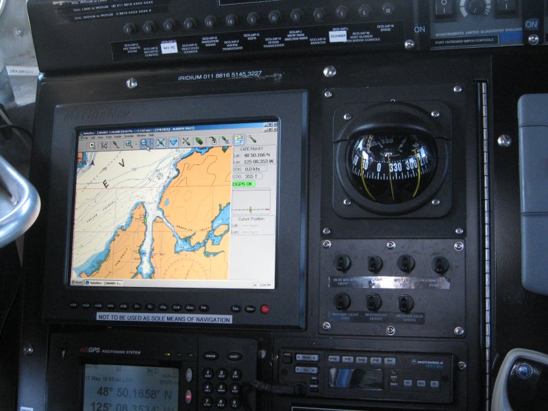
__________________
CRYA Yachtmaster Ocean Instructor Evaluator, Sail
IYT Yachtmaster Coastal Instructor
As I sail, I praise God, and care not. (Luke Foxe)
|
|
|
|
|
30-06-2019, 14:27
|
#74
|
|
Registered User
Join Date: Jul 2018
Location: SF Bay Area
Boat: Other people's boats
Posts: 1,108
|
Re: Paper Charts or Just Electronic
Quote:
Originally Posted by Simi 60
But if electronic charts are derived from the same information that the paper charts are, the information is going to be the same.
|
The data may be the same, but how it is presented may differ. It's also important to remember that the shared information you mentioned does not include the boat position relative to the charted objects.
|
|
|
|
|
30-06-2019, 15:26
|
#75
|
|
Registered User
Join Date: Jul 2005
Location: Bellingham
Boat: Outbound 44
Posts: 9,319
|
Re: Paper Charts or Just Electronic
Quote:
Originally Posted by Kenomac
One needs to have an understanding of how to use paper charts in order to understand when things arent going as planned.
Example: While rounding the north eastern channel of Corfu last evening at 2am while watching the chartplotter and radar, the boat began to drift towards the rocks in such a way as to overcome the auto pilots ability to compensate. I knew immediately current was the cause and took control.
Someone only knowing how to use an electronic chartplotter... might not have figured it out in time. Probably would have wasted valuable time screwing around with the chartplotter. |
This seems like an odd example. I must be missing something here. The continuously updated bread crumb trail on a chartplotter would make it very obvious what your actual track is. The occasional plotting of your position on a paper chart would eventually make it obvious.
|
|
|
|
|
|
| Thread Tools |
Search this Thread |
|
|
|
| Display Modes |
Rate This Thread |
 Linear Mode Linear Mode
|
|
 Posting Rules
|
You may not post new threads
You may not post replies
You may not post attachments
You may not edit your posts
HTML code is Off
|
|
|
|
Advertise Here

 Recent Discussions Recent Discussions |
|
|
|
|
|
|
|
|
|
|
|
|
|
|
|
|
|
|
|
|
|
|
|
|
|
Vendor Spotlight |
|
|
|
|
|
|
|
|
|


