 |
|
 27-01-2012, 19:17
|
#46
|
|
Registered User

Join Date: Jun 2010
Boat: Gemini 105Mc+
Posts: 920
|
Re: Garmins do not match
I have an older Garmin 178C chart plotter and a newer GPSmap 76 CSx, both WAAS enabled but they show slightly different locations
lat is off by 15" and lon off by 32" here in the Bahamas
Their "accuracy" is showing within +/- 2 ft. Just makes me a little uncomfortable when passing close to rocks or reefs.
|

|

|
|
27-01-2012, 19:19
|
#47
|
|
Registered User
Join Date: Oct 2010
Location: Wandering the US Gulf Coast
Boat: 78 Pearson323 Four Winds
Posts: 2,212
|
Re: Navigation Trouble
Quote:
Originally Posted by Seaduction

Do we as yet know how he knew the gps was 200 ft in error??? I like to start at the beginning. |
Not my place to speak for the OP, but I suspect it was noticed the same way I noticed the offset on mine.
Had a route marked right down the middle of a narrow channel, but if I motored on the route path I could easily see by eye that I was offset in the channel to one side of the center. And when I motored dead center by eye, the plotter showed the offset from center of channel.
|
|
|
|
|
27-01-2012, 19:33
|
#48
|
|
always in motion is the future

Join Date: Feb 2009
Location: in paradise
Boat: Sundeer 64
Posts: 18,961
|
Re: Navigation Trouble
Hubris!
Complacency!
Succumbed to the sirens call of technology that infects us with hubris and invites us to sail at the edge of disaster.

ciao!
Nick.
|
|
|
|
|
28-01-2012, 06:54
|
#49
|
|
Registered User
Join Date: Jul 2011
Location: Mexico City
Boat: Negotiating purchase of 2nd hand yacht
Posts: 460
|
Re: Navigation Trouble
Quote:
Originally Posted by s/v Jedi
Hubris!
Complacency!
Succumbed to the sirens call of technology that infects us with hubris and invites us to sail at the edge of disaster.
ciao!
Nick. |
+1 
__________________
When I was a boy my momma would send me down to the corner store with $1 and I would come back with 5 potatoes, 2 loaves of bread, 3 bottles of milk, a hunk of cheese, a box of tea and 6 eggs. Can't do that now, too many f**kn security cameras.
|
|
|
|
|
28-01-2012, 12:10
|
#50
|
|
Registered User
Join Date: Aug 2009
Location: between the devil and the deep blue sea
Boat: a sailing boat
Posts: 20,437
|
Re: Garmins do not match
Quote:
Originally Posted by Sailorman Ed
(...) lat is off by 15" and lon off by 32" here in the Bahamas. Their "accuracy" is showing within +/- 2 ft. Just makes me a little uncomfortable when passing close to rocks or reefs. |
1) One of your units may be shot: '15'' off' is, if I read it correctly, roughly 0.25 Nm (korrekt?). Perhaps go to a place that is where it is (many lighthouses are, some bars too), fire up both units and watch which one is the offending one.
2) While going there, remember: inshore a boat is expected to be piloted and this equals looking at GPS screen only if and when the fog is dense (I think not likely at Bahamas). Otherwise, in reef and coral country, the pilot should be out there on the bridge (in the cockpit) watching the landmarks, the water and the nav aids. The GPS is an optional and welcome reference, not the sole basis, of navigation. This attitude should make you a little MORE comfortable.
Blah blah blah. You know me;-)
Cheers,
b.
|
|
|
|
|
28-01-2012, 12:19
|
#51
|
|
Registered User
Join Date: Jul 2006
Location: Massachusetts
Boat: Finnsailer 38
Posts: 5,282
|
Re: Navigation Trouble
B: I once answered someone calling for help on the radio in the Bahamas because his GPS chartplotter position didn't match up with his radar image. I asked where he was and he told me and I promptly answered to stop looking at either and instead use his eyeballs to look up ahead because he was two miles from Marsh Harbour and it was a perfect sunny Bahamas day.
|
|
|
|
|
28-01-2012, 13:06
|
#52
|
|
Registered User
Join Date: Nov 2011
Location: Montegut LA.
Boat: Now we need to get her to Louisiana !! she's ours
Posts: 3,421
|
Re: Navigation Trouble
Just remember GPS is a TOOL as are charts,dividers,binoculars, compass,sextant, and eyeballs and even your nose when needed ! if all you use is one of your tools, you are bound to make mistakes sometimes! I still use paper charts everyday at sea. I know Im old fashion, but i still use all of my tools at sea! hand held Gps to ck my noon sites, The Capt mapping program on laptop,(mostly Connie uses this system)and I will use star site when its easy to get them. and eyes and ears and nose, depth finder, even my old favorite a lead line with a wax bottom when approching a coastal harbor, or anchorage. If you learn to use all the tools you have your going to have a much safer cruise or even a daysail!! just the opinion of someone OLD but still alive after 60 yrs of sailing safely useing all the tools I have ! Bob and Connie
|
|
|
|
|
28-01-2012, 14:02
|
#53
|
|
Registered User
Join Date: Sep 2007
Location: Cayuga Lake NY - or on the boat somewhere south of there
Boat: Caliber 40
Posts: 1,355
|
Re: Navigation Trouble
I am amazed at some of the "holier than thou" attitudes in this thread. For heavens sake, the guy didn't run aground. That means he may have been using his eyes. Or a paper chart. Or both. So, given the behavior I have seen on occasion where people actually ran aground because they were glued to their plotter, THIS guy seems to actually have some sense.
And on Garmin plotters, mine is usually very close to spot on but there was a place in the ICW last year where it showed me on dry land when I obviously wasnt. That happens occasionally. Yet another reason to actually watch where you are going.
|
|
|
|
|
28-01-2012, 16:10
|
#54
|
|
Registered User
Join Date: Aug 2008
Location: Hawaii
Boat: CS 40
Posts: 171
|
Re: Garmins do not match
Quote:
Originally Posted by barnakiel
remember: inshore a boat is expected to be piloted and this equals looking at GPS screen only if and when the fog is dense (I think not likely at Bahamas). Otherwise, in reef and coral country, the pilot should be out there on the bridge (in the cockpit) watching the landmarks, the water and the nav aids. |
I couldn't agree more although I do rely almost exclusively on electronic charts. The tempting belief that the ship icon on the chart plotter is actually where your boat is can lead to problems. Been there, done that. 
__________________
Michael Fössl
S/V Second Jump
British Columbia
|
|
|
|
|
01-02-2012, 04:55
|
#55
|
|
Registered User
Join Date: Jan 2010
Posts: 120
|
Re: Navigation Trouble
Quote:
Originally Posted by Mexdon
Originally Posted by s/v Jedi
Hubris!
Complacency!
Succumbed to the sirens call of technology that infects us with hubris and invites us to sail at the edge of disaster.
ciao!
Nick.
+1
|
Whistle past fate that ignorance brings all you want Nick.
But, in the meantime...
Seems the the Sirens have bagged another unwary soul:
Three people were rescued from a life raft last night in waters in the Abel Tasman National Park, after their 12 metre yacht hit rocks near Torrent Bay.
Maritime New Zealand spokesman Ross Henderson said the Okiana sunk around midnight last night, after it hit rocks off Pitt Head reef, at the entrance to Torrent Bay and Anchorage.
He said the three people on board set off an emergency beacon and put out a distress call, because the vessel was taking on water.
Got this from over at Sailing Anarchy...They also have some nice big pictures up.
|
|
|
|
|
01-02-2012, 06:44
|
#56
|
|
Registered User
Join Date: Dec 2006
Location: Seattle
Boat: Cal 40 (sold). Still have a Hobie 20
Posts: 2,945
|
Re: Navigation Trouble
You got me curious so I did a little Googling.
This NOAA link says that 99% of all NOAA charts are WGS84. Also says RNCs are exact copies of the paper chart. My conclusion to this is 1% of NOAA RNCs are not WGS84 as they would have to change the lat/long markings on the chart to change the chart to WGS84.
Says prior to 90s was pre GPS so chart accuracy was different then.
NOAA's take (warnings) on accuracy:
DGPS and your chart
DGPS & Your Chart
Some ramblings.
I was an electronics work-study student at NOAA in the early 80s. Was shown that the computers I was learning to repair were PDP 8s that were on 20 foot survey boats. These were used to collect survey data. They would place a loran like transmitter on a pole, back the survey vessel up to it then drive off in a straight line. Receiver would count wave cycles away from known position of pole, PDP8 recorded distance from pole and depth (and heading? not sure). They were still charting parts of Alaska at that time. Had a nice picture of a survey boat on a rock with the tide 30 feet out below it.
Quote:
Originally Posted by Kettlewell
bcaldoc, to reiterate what some helpful people up thread wrote, I believe all current NOAA charts are WGS84 datum, but it is possible that for some reason your GPS unit has been reset to another datum, which could cause position errors. Somewhere in your instruction book or online you can find information on how to check what datum your GPS unit is set to, and you should readjust it to WGS84. Not every chart in the world is WGS84--once you leave the USA you may have to reset your GPS to match some charts, particularly very old charts you might find in places like the South Pacific. |
|
|
|
|
|
01-02-2012, 06:59
|
#57
|
|
Registered User
Join Date: Jan 2010
Posts: 120
|
Re: Navigation Trouble
Quote:
Originally Posted by cal40john
You got me curious so I did a little Googling.
This NOAA link says that 99% of all NOAA charts are WGS84. Also says RNCs are exact copies of the paper chart. My conclusion to this is 1% of NOAA RNCs are not WGS84 as they would have to change the lat/long markings on the chart to change the chart to WGS84.
|
An uncorrected GPS point plotted on a chart based on a datum other than NAD-83/WGS-84 is a real Siren Song
|
|
|
|
|
01-02-2012, 07:31
|
#58
|
|
always in motion is the future
Join Date: Feb 2009
Location: in paradise
Boat: Sundeer 64
Posts: 18,961
|
Re: Navigation Trouble
Quote:
Originally Posted by sidmon
An uncorrected GPS point plotted on a chart based on a datum other than NAD-83/WGS-84 is a real Siren Song
|
This is one of the best examples of complete incompetence that I ever read about. Idiots should be kept away from positions where they can cause harm.
ciao!
Nick.
|
|
|
|
|
01-02-2012, 08:12
|
#59
|
|
Registered User
Join Date: Jan 2010
Posts: 120
|
Re: Navigation Trouble
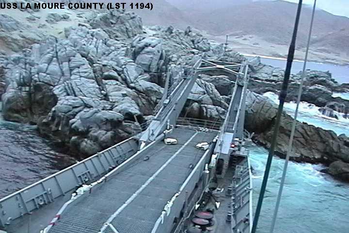
The skipper of the La Moure County was a naval aviator in his "deep draft command"...
A little digression: By US law, only Naval Aviators can be in command of aircraft carriers, so those selected are assigned to command an auxiliary or an amphibious warfare ship like the La Moure County so they can gain surface ship command experience (and before you go off on yet another wrong tangent here, they have already commanded at least one aircraft squadron, and also have carrier conning experience as they have also served as XO -second in command- of one).
And carrier command usually portends selection as Admiral. Needless to say its a hyper competitive process, and you don't get considered unless you are at the top of the top in ability, smarts, acumen...And luck (which most have mastered the knack of manufacturing for themselves).
So, your hypothesis (like so many of yours) is wrong in this case. Folks like that hapless captain are among the sharpest folks to be had. What befell this unfortunate gent was a lack of navigation training in his command.
And its a lesson that not just the OP of this thread, but all here including you (and me), should heed.
lest those Sirens get yah.
|
|
|
|
|
01-02-2012, 08:34
|
#60
|
|
Senior Cruiser
Join Date: Oct 2007
Location: San Antonio, TX/Bocas del Toro, Panama
Boat: 1990 Macintosh 47, "Merlin"
Posts: 2,844
|
Re: Navigation Trouble
My uncle was a Navy Oceanographer. He captained one of the Navy's cartography ships. I have a full set of Caribbean charts, about half of which he personally surveyed (he signed the ones he did). BTW, his daughter is also an Annapolis-trained oceanographer, but she's soon to in command of a Carrier Air Wing...
Anyway, these charts do NOT match GPS coordinates without a proper correction. The fact is, the islands on the charts are all in the right place in relation to each other, but they are just not THAT accurate. Hundreds of feet, is close.
|
|
|
|
|
|
| Thread Tools |
Search this Thread |
|
|
|
| Display Modes |
Rate This Thread |
 Linear Mode Linear Mode
|
|
 Posting Rules
|
You may not post new threads
You may not post replies
You may not post attachments
You may not edit your posts
HTML code is Off
|
|
|
|
Advertise Here

 Recent Discussions Recent Discussions |
|
|
|
|
|
|
|
|
|
|
|
|
|
|
|
|
|
|
|
|
|
|
|
|
|
Vendor Spotlight |
|
|
|
|
|
|
|
|
|


